Hampshire Council of Governments Records

1677-1961
90 vols., 17 boxes (80 linear foot)
Call no.: MS 704
rotating decorative images from SCUA collections

The Hampshire Council of Governments is a voluntary association of cities and towns and the successor to the former government of Hampshire County, Massachusetts, that was abolished in 1999. A body politic and corporate, its charter ratified by Massachusetts General Law 34B, S20(b), the Council oversees roadways, the electricity supply, building inspection, tobacco control, cooperative purchasing, and other services for member communities.


The Hampshire Council collection contains a dense record of county-level governance in western Massachusetts from the colonial period through the mid-twentieth century with extensive documentation of the actions of the County Commissioners, and before them the Court of Common Pleas and Court of General Sessions. Rich in documenting the development of the transportation infrastructure of western Massachusetts, the collection offers detailed information associated with the planning and construction of highways, canals, ferries, and railroads, but the early records offer a broad perspective on the evolution of the legal and cultural environment, touching on issues from disorderly conduct (e.g., fornication, Sabbath breaking) to the settlement of estates, local governance, public works, and politics.

See similar SCUA collections:

Background on Hampshire Council of Governments
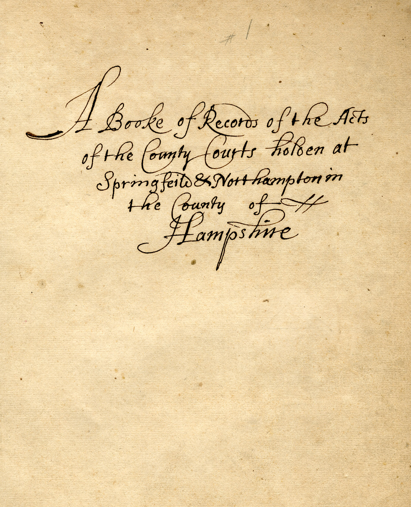

An image of: Titlepage, vol. 1

Titlepage, vol. 1

From the mid-1630s, European settlement of western Massachusetts progressed northward up the Connecticut River Valley, spreading gradually to the east and west. Under the authority of the General Court in Boston, Hampshire County was established in 1662 with courthouses in the two largest settlements, Springfield and Northampton, assuming jurisdiction over most of the current-day Commonwealth west of Worcester. Civil authority was administered through a three-tiered system in which magistrates (later justices of the peace) dispensed justice at the local level, above which sat a system of county-level courts and the General Court and Court of Assistants in Boston (later the Governor and Council).

County-level courts bore much of the responsibility for regional administration, ranging from laying out highways, roads, ferries, dams, and bridges to licensing taverns, inns, and retailers; keeping jails; and maintaining local order. Civil suits exceeding 40 shillings but less than ten pounds were heard in the Inferior Court of Common Pleas, while the Court of General Sessions, composed of a quorum of local justices, heard most non-capital criminal cases. For more serious crimes, including capital offences, cases were referred to the Superior Court of Judicature, a circuit court established in 1692 that met in each county as designated by the legislature.

As the population of western Massachusetts increased, Hampshire County was divided several times into smaller, more manageable bodies. The eastern part was separated out as Worcester County by act of the legislature on April 2, 1731, followed by the separation of the west into Berkshire County on April 21, 1761. Sandwiched in between Worcester and Berkshire, the remains of Hampshire County were further divided horizontally into thirds, with the northern portion becoming Franklin County (June 24, 1811) and the southern, Hampden County (Feb. 25, 1812) in which Springfield served as county seat.

The political evolution of the Commonwealth led to other changes in the system of county courts and administration, particularly after the state constitution of 1780 mandated a complete separation of legislative, judicial, and executive functions. In 1821, Massachusetts established a state-wide Court of Common Pleas and within three years, all judicial powers of the Court of General Sessions were transferred to that Court and the administrative powers were delegated to a newly created body of County Commissioners and Commissioners of Highways. After the Court of General Sessions was abolished in 1827, the County Commissioners in Hampshire County assumed responsibility for the administrative functions of the General Sessions as well. Ultimately, the Court of Common Pleas was abolished altogether during further reorganization in 1859, with most of its trial functions delegated to the new, state-wide Superior Court.

By the last decade of the twentieth century, many county governments had become little more than vestiges of their former selves, with judicial and administrative functions having been absorbed by operations of the towns or by the state government. When Middlesex County reached a point of near insolvency in June 1997 and dissolved, it set off a period of three years in which eight of the fourteen county governments in Massachusetts were laid down and others were substantially reorganized.

Hampshire County was officially abolished on Jan. 1, 1999, and many of its responsibilities were reorganized under the Hampshire Council of Governments as a voluntary association of cities and towns. Chartered under Massachusetts General Law 34B, S20(b), the Hampshire Council is a body politic and corporate that oversees basic services for its member communities, including roadways, the electricity supply, building inspection, tobacco control, and cooperative purchasing.
Scope of collection

The Hampshire Council collection contains a dense record of county-level governance in western Massachusetts from the colonial period through the mid-twentieth century with extensive documentation of the actions of the County Commissioners, and before them the Court of Common Pleas and Court of General Sessions. Rich in documenting the development of the transportation infrastructure of western Massachusetts, the collection offers detailed information associated with the planning and construction of highways, canals, ferries, and railroads, but the early records offer a broad perspective on the evolution of the legal and cultural environment, touching on issues from disorderly conduct (e.g., fornication, Sabbath breaking) to the settlement of estates, local governance, public works, and politics. Because of the intensely local nature of the records, the collection offers some insight into the daily lives of women as well as men, Native Americans and African Americans as well as whites, rich and poor, and urban and rural.

The collection is divided into four series: County Commissioners and Court Records, Dockets, Maps and Plans, and Microfilm. This finding aid contains only a preliminary listing of contents and will be added to as processing progresses. As materials are digitized, we will provide links to the online records through the inventory below.

Series descriptions

The records of the Inferior Court of Common Pleas, the Court of General Sessions for the Peace, and the Hampshire County Commissioners are a remarkable, continuous record of county-level governance in western Massachusetts for nearly three centuries. Until 1812, Hampshire County administered most of the western half of the Commonwealth, and the records are consequently broad, geographically and culturally. Beginning shortly after the end of King Phillips War, they document the establishment of political and cultural order during the late 17th century, the period of the Second Great Awakening, the Revolution, Shays Rebellion, and War of 1812. The content relates to all aspects of the operations of county-level administration, including licensure, building roads and infrastructure, and in early years, the record books document civil and occasionally criminal infractions.

Until 1828, each bound volume contains the interspersed records of meetings of both the Court of General Sessions and Inferior Court of Common Pleas. When the Courts of General Sessions were abolished in Feb. 26, 1828, the corresponding volume records that the legislature "transferred the powers and duties lately rested in and exercised by" that court to the newly formed County Commissioners, and from that point onward, the volumes are restricted to the Hampshire County Commissioners, and are correspondingly narrower in scope.

1677-1961
17 boxes

The dockets are comprised of filings relating to proceedings documented in the record books (Series 1). Consisting primarily, though not exclusively, of original letters and associated documents, these often provide greater detail than the record books. Overwhelmingly, the dockets center on road construction in the early years.

The County Commissioners maintained working maps of the towns and counties to document the creation, extension, relocation, alteration, or discontinuance of county roads through the various towns, as well as similar maps for railroad routes (including lands taken and location of route), dams, and bridges. Each proposed action was accompanied by a map documenting the changes, usually a relatively detailed technical drawing with little embellishment. The Commissioners also maintained commercial maps and atlases of the county and towns.

The vast majority of maps in the series date from the mid- to late-twentieth century, however most of the railroad maps correspond to an earlier period of expansion and extend back as far as the establishment of the first rail lines through the region. Dams and bridges are less well documented, although a series of reports on dam inspections between the 1920s and 1950s include valuable detail. A few items in the series are worthy of particular note, including a broadside proclamation from Governor James Bowdoin, Feb. 17, 1787, regarding persons who had been disqualified for taking part in Shays Rebellion; an early atlas containing manuscript maps of county highways (1759-1838); and two volumes relating to the reconstruction of Williamsburg after the Mill River flood of 1874, the Plan for a Proposed Dam at the Williamsburg Reservoir and Williamsburg Road Plans.

Most of the maps are tightly rolled and many are in poor condition, embrittled, and often torn and chipped. All require special care in handling.

1839-1969
116 reels

In addition to microfilm of the volumes comprising Series 1, the collection includes microfilm of materials held elsewhere. Included are indexes to the county records, records of civil actions in the Superior Court (1856-1908), records of the Supreme Judicial Court (1797-1954), the Registry of Probate (1660-1820), a small sampling of records from the Registry of Deeds (1859-1860), and naturalization records (1849-1934).

The records appear to have been filmed on more than one occasion and duplicate reels have not been inventoried.

Inventory

Series 1. County Commissioners and Court Record Books
1677-1961
Court of General Sessions and Inferior Court of Common Pleas Records
1677-1837

Includes lists of executions, 1716-1765.

Inferior Court of Common Pleas and Court of General Sessions of the Peace. Vol. 19 not scanned due to fragility of original


Cab. 10

Includes lists of writs of execution, 1715-1764, pp.1-80.

County Commissioners Records
1837-1961
1837-1844
Cab. 11
1844-1852
Cab. 11
1852-1860
Cab. 11
1860-1867
Cab. 11
1868-1871
Cab. 11
1871-1875
Cab. 11
1876-1880
Cab. 11
1881-1882
Cab. 11
1883-1886
Cab. 11
1887-1889
Cab. 11
1890-1894
Cab. 11
1895-1900
Cab. 11
1901-1906
Cab. 11
1907-1910
Cab. 11
1911-1916
Cab. 11
1917-1923
Cab. 11
1923-1929
Cab. 11
1929-1935
Cab. 11
1935-1940
Cab. 11
1940-1945
Cab. 11
1945-1950
Cab. 11
1950-1954
Cab. 11
1954-1958
Cab. 11
1958-1961
Cab. 11
County Commissioners Records, Vol. 27
1961-1965
County Commissioners Records, Vol. 28
1965-1969
County Commissioners Records, Vol. 29
1969-1975
Series 2. Dockets
1677-1984
Hampshire County Dockets (loose-leaf)
1677-1961
Box 1
Hampshire County Dockets
Box 1
Hampshire County Dockets
Box 2
Hampshire County Dockets
Box 3
Hampshire County Dockets
Box 4
Hampshire County Dockets
Box 5
Hampshire County Dockets
Box 6
Hampshire County Dockets
Box 7
Hampshire County Dockets
Box 8
Hampshire County Dockets
Box 9
Hampshire County Dockets
Box 10
Hampshire County Dockets
Box 11
Hampshire County Dockets
Box 12
Hampshire County Dockets
Box 13
Hampshire County Dockets
Box 14
Hampshire County Dockets
Box 15
Hampshire County Dockets
Box 16
Dockets
Box 17
County Commissioners' Dockets (bound)
1825-1988
County Commissioners' Dockets (bound)
1825-1841
Du Bois Room
County Commissioners' Dockets (bound)
1841-1846
Du Bois Room
County Commissioners' Dockets (bound)
1847-1852
Du Bois Room
County Commissioners' Dockets (bound)
1853-1858
Du Bois Room
County Commissioners' Dockets (bound)
1859-1865
Du Bois Room
County Commissioners' Dockets (bound)
1866-1870
Du Bois Room
County Commissioners' Dockets (bound)
1871-1874
Du Bois Room
County Commissioners' Dockets (bound)
1875-
Du Bois Room
County Commissioners' Dockets (bound)
Du Bois Room
County Commissioners' Dockets (bound)
1878-1884
Du Bois Room
County Commissioners' Dockets (bound)
1885-1889
Du Bois Room
County Commissioners' Dockets (bound)
1890-1894
Du Bois Room
County Commissioners' Dockets (bound)
1895-1899
Du Bois Room
County Commissioners' Dockets (bound)
1900-1903
Du Bois Room
County Commissioners' Dockets (bound)
1904
Du Bois Room
County Commissioners' Dockets (bound)
1905
Du Bois Room
County Commissioners' Dockets (bound)
1906
Du Bois Room
County Commissioners' Dockets (bound)
1907
Du Bois Room
County Commissioners' Dockets (bound)
1908
Du Bois Room
County Commissioners' Dockets (bound)
1909
Du Bois Room
County Commissioners' Dockets (bound)
1910
Du Bois Room
County Commissioners' Dockets (bound)
1911
Du Bois Room
County Commissioners' Dockets (bound)
1912
Du Bois Room
County Commissioners' Dockets (bound)
1913
Du Bois Room
County Commissioners' Dockets (bound)
1914
Du Bois Room
County Commissioners' Dockets (bound)
1915
Du Bois Room
County Commissioners' Dockets (bound)
1916
Du Bois Room
County Commissioners' Dockets (bound)
1917
Du Bois Room
County Commissioners' Dockets (bound)
1918
Du Bois Room
County Commissioners' Dockets (bound)
1919
Du Bois Room
County Commissioners' Dockets (bound)
1919
Du Bois Room
County Commissioners' Dockets (bound)
1922-1924
Du Bois Room
County Commissioners' Dockets (bound)
1925-1926
Du Bois Room
County Commissioners' Dockets (bound)
1927-1929
Du Bois Room
County Commissioners' Dockets (bound)
1930-1932
Du Bois Room
County Commissioners' Dockets (bound)
1933-1936
Du Bois Room
County Commissioners' Dockets (bound)
1936-1938
Du Bois Room
County Commissioners' Dockets (bound)
1938-1940
Du Bois Room
County Commissioners' Dockets (bound)
1940-1943
Du Bois Room
County Commissioners' Dockets (bound)
1943 Mar.-1946 Mar.
Du Bois Room
County Commissioners' Dockets (bound)
1943 Mar.-1949 Mar.
Du Bois Room
County Commissioners' Dockets (bound)
1949 Mar.-1951 Mar.
Du Bois Room
County Commissioners' Dockets (bound)
1951 Mar.-1954 Mar.
Du Bois Room
County Commissioners' Dockets (bound)
1954 Mar.-1956 Sept.
Du Bois Room
County Commissioners' Dockets (bound)
1956 Sept.-1958 Sept.
Du Bois Room
County Commissioners' Dockets (bound)
1958 Sept.-1960 (inc.)
Du Bois Room
County Commissioners' Dockets (bound)
1960 June-1962 June
Du Bois Room
County Commissioners' Dockets (bound)
1962 June-1964 June
Du Bois Room
County Commissioners' Dockets (bound)
1964 June-1966 June
Du Bois Room
County Commissioners' Dockets (bound)
1966 June-1968 Mar.
Du Bois Room
County Commissioners' Dockets (bound)
1968 Sept.-1970 June
Du Bois Room
County Commissioners' Dockets (bound)
1970 Sept.-1973 Mar.
Du Bois Room
County Commissioners' Dockets (bound)
1973 Mar.-1976 June
Du Bois Room
County Commissioners' Dockets (bound)
1976 Sept.-1979 June
Du Bois Room
County Commissioners' Dockets (bound)
1979 Sept.-1981 Dec.
Du Bois Room
County Commissioners' Dockets (bound)
1982 Mar.-1984 Dec.
Du Bois Room
County Commissioners' Dockets (bound)
1985 Mar.-1986 Dec.
Du Bois Room
County Commissioners' Dockets (bound)
1987 Mar.-1988 Dec.
Du Bois Room
Series 3. Maps and Miscellaneous Materials
1839-1969
Atlases
1870-1969
11 titles
Highway Plans, County of Hampshire, vol. 1
1759-1838
Du Bois Room

Manuscript maps depicting early roads in Hampshire County. Labeled vol. 1 (all that is present).

Atlas of Hampden County (Beers, 1870)
Cab. 1:6
Atlas of Hampshire County (Beers, 1873), rebound
1873
2 copies
Cab. 1:11
Atlas of Hampshire County (Beers, 1873). Note: poor condition, use rebound copies
1873
2 copies
Cab. 1:6
Atlas of Massachusetts (Walker, 1891)
1891
Cab. 1: top
Atlas of Northampton and Easthampton
1895
Cab. 1: top
Atlas of Northampton City
1884
Cab. 1: top
Atlas of Surveys, Hampden County, Massachusetts (Richards, 1894)
1894
Cab. 1: top
Atlas of the Boundaries...
1912-1915
4 vols.
Cab. 1: top
County Roads in Hampshire County (one copy with blueprints laid in)
1922
3 copies
Cab. 1: top
Guyot, Arnold, Johnson's New Illustrated Family Atlas of the World
1882
Cab. 1: top
Town Atlas, Town of Amherst, Massachusetts
1969
Cab. 1:11
Bridges, Buildings, and Dams
1870-1969
11 titles
Bridges
2 drawers
Cab. 1
Dam data
Cab. 6
Dams (Amherst, Belchertown, Chesterfield, Cummington, Easthampton, Goshen, Granby, Hadley, Hatfield)
Cab. 6
Dams (Holyoke, Huntington, Middlefield, Northampton)
Cab. 6
Dams (South Hadley)
Cab. 6
Dams (Southampton)
Cab. 6
Dams (Ware, Westhampton, Williamsburg, Worthington)
Cab. 6
Plan for a Proposed Dam at the Williamsburg Reservoir
1875
Cab. 1: top
Plans of the Parish House, Pliny Earle, Northampton
ca.1865
Cab. 1: top
United States Geological Survey topographical maps
Cab. 1: top
Williamsburg Road Plans
1874
Cab. 1: top
Reports on County Dams: Federal Communications Commission Rules and Regulations
1961
Cab. 5: box 1
Reports on County Dams: Inspection Reports on the Tighe-Carmody Reservoir of the Holyoke Water Works in Southampton
1963-1968
Cab. 5: box 1
Reports on County Dams
1924-1928
Cab. 5: box 1
Reports on County Dams
1928-1954
Cab. 5: box 1
Reports on County Dams
1955-1956
Cab. 5: box 1
Reports on County Dams
1957-1958
Cab. 5: box 1
Reports on County Dams
1959-1960
Cab. 5: box 2
Reports on County Dams
1961-1962
Cab. 5: box 2
Reports on County Dams
1963-1965
Cab. 5: box 2
Commonwealth of Massachusetts, by his Excellency James Bowdoin, Esq., Governour of the Commonwealth of Massachusetts, A Proclamation
1787 Feb. 17
Broadside

Evans 20501. "Whereas by an act passed the sixteenth of February instant, entitled, 'An act describing the disqualifications, to which persons shall be subjected, which have been, or may be guilty of treason ... and to whom a pardon may be extended'... Given at the council chamber in Boston, this seventeenth day of February ... one thousand seven hundred and eighty-seven."

State/County Highways and Roads: Indexes and Plans
1730-1989
Road indexes
1730-1902
Du Bois Room
Road table: Index
1829
Mss
Du Bois Room
General orders to the County Commissioners records for highway locations [index to county roads]
Du Bois Room
Index to highway alterations
1860-1902
Du Bois Room
County Highways: Amherst
Cab. 2
Amherst: Petition for the alteration in width of Station Rd., as the intersection of Station Rd. & South East St.
1846 May
Cab. 2(a)

Amherst: East Leverett Rd.
1870
Cab. 2(a)

Proposed road from Hadley to Amherst

Amherst : Pine St.
1873
Cab. 2(a)

Amherst: Lincoln Ave from Amity St. to Fearing St.
1937
Cab. 2(a)

Map of the Town of Amherst, Mass.

Amherst: Layout of North Pleasant St.
1919 Sep. 11
Cab. 2(a)

33: Alteration of South Pleasant Street at Mill Valley

Amherst: Plan of bridge crossing and highway at Mill Valley
1921 Mar.
Cab. 2(a)

12

Amherst: Belchertown Rd.
1924 Dec.. 5
Cab. 2(a)

214: Takings on Amherst-Pehlam-Belchertown layout

Amherst: Plan and description of Takings on this layout are shown in plan and on files of of 9.214
1925 Aug. 11
Cab. 2(a)

302

Amherst: Relocation of Market Hill Rd., together with discontinuance of a portion of Henry St.
1926 Jun. 1
Cab. 2(a)

Amherst: Layout of North East Street (formerly Flat Hills Rd.)
1931 Sep. 9
Cab. 2(a)

890: Relocation East Leverett Rd.

Amherst: Relocation of a portion of Triangle St.
1933 Jun. 13
Cab. 2(a)

1041

Amherst: Discontinuance of Belchertown Rd.
1934 Jun. 12
Cab. 2(a)

1117: Plan of Pine Street

Amherst: Station Rd.,
1938 Nov. 12
Cab. 2(a)

1513

Amherst: Portion of North Hadley Rd.
1941 Apr. 30
Cab. 2(a)

1727

Amherst: Proposed relocation of South Pleasant St. between Walnut St. and R.R.
1947 Aug. 1
Cab. 2(a)

2380

Amherst: Layout of portion of North Hadley Rd.
1948 May 21
Cab. 2(a)

2417

Amherst : Plan of layout of Clifton Ave.
1948 Nov. 26
Cab. 2(a)

2525

Amherst: Pine St.
1951 May 16
Cab. 2(a)

2835

Amherst: South Pleasant St.
1956 Feb. 20
Cab. 2(a)

10

Amherst: Mill Le.
1957 Apr. 26
Cab. 2(a)

3568

Amherst: Layout of North Pleasant St.
1960 Sep. 16
Cab. 2(a)

3723: Relocaiton of Mill Lane

Amherst: Relocation of Bay Rd.
1961 Jun. 9
Cab. 2(a)

3997

Amherst: Relocation of East Pleasant St.
1962 Jul. 27
Cab. 2(a)

4272

Amherst: Relocation of Bridge St., State St., Leverett Rd., and East Leverett Rd., for the reconruction of Cushman Bridge
1963 Aug. 6
Cab. 2(a)

4280

Amherst: Relocation, Alteration of East Hadley Rd.
1964 Nov. 6
Cab. 2(a)

4586

Amherst : Proposed road from Mill Valley to South Amherst (Shays St.)
1966 Feb. 1
Cab. 2(a)

4775

Amherst: South East St., relocation of a portion Sta. 45. to Sta. .50
1966 Sep. 30
Cab. 2(a)

4840

Amherst: Alteration of Bay Rd.
1967 Jul. 28
Cab. 2(a)

4937

Amherst: Sketch of Linehan property
1969 Jun. 6
Cab. 2(a)

5064

Amherst : Revised plan of Strong Street layout
1969 Sep. 26
Cab. 2(a)

5132

Amherst: Alteration of two sections of Bay Rd.
undated
Cab. 2(a)

4839: Hamp County, Reg. of Deeds plan book, 70 page 29-38

Amherst: Layout, alteration of Granby Rd. (also known as Harris Mountain Rd.)
undated
Cab. 2(a)

5132

Amherst: Sunderland Rd. (Route 116) Beginning at Sunderland town line (Sta. 280+91.59 and extending SE to Sta. 284+39.24)
undated
Cab. 2(a)

6635

County Highways: Belchertown
Cab. 2
Belchertown: Layout, relocation, alteration & discontinuance of Bay Rd. (Sta.0+0 to Sta. 34+0 at the intersection of Warren Wright Rd.
1924 Dec. 5
Cab. 2(b)

214: Amherst-Pelham-Belchertown Layout

Belchertown: Relocation of Turkey Hill Rd. (Route 21) from Sta. 98+09.30 to Sta.140+30.75, being a new cutoff
1925 Apr. 7
Cab. 2(b)

260: Also says Mar 6 1925

Belchertown: Plan of layout of Bay Road showing conrete bounds
1925 Sep. 23
Cab. 2(b)

260

Belchertown: Turkey Hill Rd. from Sta. 153.06.09 to Sta. 198+45.74
1925 Sep. 23
Cab. 2(b)

260: Sta. 232+23.85 to Sta. 346

Belchertown: Sargent St.
1931 Jun. 25
Cab. 2(b)

884

Belchertown: Layout relocation, alteration or discontinuance of a portion of Chauncy Walker St. from Station 89+00 to Station 105+50, a distance of approximately 1600 ft
1931 Aug. 31
Cab. 2(b)

889

Belchertown : Discontinuance of Sabin St. from Station 0+00 to Station 6+82+ a distance of approximately 682 ft
1934 Jun. 12
Cab. 2(b)

1117

Belchertown: Reconstruction of Jackson St. at Railroad Crossing
1937 Apr. 28
Cab. 2(b)

940

Belchertown: Alteration and relocation of bay Rd.
1938 Jul. 16
Cab. 2(b)

1473

Belchertown: Ocean Road to Lake Metacomet
1954 Nov. 12
Cab. 2(b)

3224

Belchertown: Amherst Rd.
1954 Dec. 1
Cab. 2(b)

3109

Belchertown: Plan of relocation of Bondsville Rd.
1959 Oct. 2
Cab. 2(b)

3859

Belchertown : Discontinuance of a portion of Bay Rd. from Station 0+38+ to Station 1+28 of the Metacomet St. Baseline, a distance of 90 feet, more or less
1959 Nov. 6
Cab. 2(b)

3888

Belchertown: Amherst Rd.
1959 Dec. 4
Cab. 2(b)

3695

Belchertown: Discontinuance of portions of Jabish Brook Rd. from Station 24+82 to Station 182+35
1962 Jul. 3
Cab. 2(b)

4248

Belchertown: Layout and Discontinuance of Blue Meadow Rd.
1966 Jul. 15
Cab. 2(b)

4834

Belchertown: Discontinuance of Jarbish Brook Rd. form Station 140+92.90 to the Daniel Shays Highway layout of March 7, 1961 to Station 152+50.00
1966 Oct. 21
Cab. 2(b)

4835

Belchertown: Plan of layout of Bondsville Rd.
1967 Apr. 15
Cab. 2(b)

1732: Showing bounds

Belchertown: Jabish Rd., Route 21
1967 Jul. 3
Cab. 2(b)

4909

Belchertown: Alteration of Route 9 so-called Amherst Rock
1969 Jun. 13
Cab. 2(b)

4930

Belchertown: Plan of discontinuane of a portion of Enoch SanfoRd. Rd.
1970 Jun. 19
Cab. 2(b)

3440: Extra copies

Belchertown: Turkey Hill Rd. from Sta. 65+77.47 to Sta. 101
1970 Jun. 19
Cab. 2(b)

5187

Belchertown: Plan of The Three Rivers Rd.
1973 Sep. 6
Cab. 2(b)

5535

Belchertown: Layout of Bay Rd.
1973 Oct. 3
Cab. 2(b)

9099: Unlabled

Belchertown: Discontinuance of a portion of Route #9 from Station 50+10.40 to Station 57+00
1974 Sep. 3
Cab. 2(b)

5618

Belchertown : Layout of Turkey Hill Rd. from Ludlow Town Line to Sta. 27+80.89
1974 Oct. 15
Cab. 2(b)

5714

Belchertown: Alteration and Relocation of Three Rivers Rd.
1974 Oct. 18
Cab. 2(b)

5713

Belchertown: Stebbins St. Station: 40.34.07 to Station 50+00.00
1975 Aug. 15
Cab. 2(b)

5830

Belchertown: Stebbins St.
1976 Mar. 23
Cab. 2(b)

5831

Belchertown : Alteration of Stebbins St. Station 50+0.00 to Belchertown-Granby Line
1976 Mar. 23
Cab. 2(b)

5832

Belchertown: Turkey Hill Rd. (route 21) from Sta 27+80.89 to Sta. 65+77.47
1978 Jan. 11
Cab. 2(b)

6035

Belchertown: Layout of Bondsville Rd. from Sta. 222+53.00 to Sta. 268+0
1982 Apr. 7
Cab. 2(b)

Unlabled, 7 sheets

Belchertown: Plan of Three Rivers Rd.
1982
Cab. 2(b)

Belchertown: Layout relocation, alteration or discontinuance of Bay Rd., Stebbins St. and a new connector Rd.
1984 Dec. 17
Cab. 2(b)

7107

Belchertown: Bay Rd.
undated
Cab. 2(b)

5829

Belchertown: Bay Rd.
undated
Cab. 2(b)

Unlabled

Belchertown: Discontinuance of Ware Rd. Station 31+70 to 93+30)
undated
Cab. 2(b)

Amherst-Belchertown Layout

Belchertown and Ware: New layout from Ware through Enfield to Belchertown
1938
Cab. 2(b)

County Highways: Chesterfield, Cummington
Cab. 2
Chesterfield: Re-Establishment of River Rd. .
1921 May 3
Cab. 2(c)

13: This plan engineered by plan filed 1921 Nov 2

Chesterfield: Plan of Worthington Rd.
1921 Jun. 10
Cab. 2(c)

13

Chesterfield: Relocation of Williamsburg Rd.
1921 Nov. 2
Cab. 2(c)

13: Sec. 1 - From Sta. 80+72.67 - Sta. 88+03.4 Sec. 2 - From Sta. 80+28.19 - Sta. 182

Chesterfield: Layout of highway at bridge in West Chesterfield on Main Rd.
1921 Dec. 27
Cab. 2(c)

Chesterfield: Souh Street alteration starting at Westhampton town line
1925 Dec. 31
Cab. 2(c)

336

Chesterfield: Main Rd. from Sta. 229-02.08 to Sta. 252
1950 May 5
Cab. 2(c)

2697

Chesterfield: Plan of Damon Pond Rd.
1952 Feb. 29
Cab. 2(c)

2868

Chesterfield: Plan of Roberts Meadow Rd.
1952 Mar. 21
Cab. 2(c)

2772

Chesterfield: Layout of Ireland Stand River Rd.
1955 Dec. 24
Cab. 2(c)

3079: Printed as 1953 but corrected to 1955

Chesterfield: Highway from Mount Rd. to highway landing from Cummington to West Chesterfield
1961 Mar. 24
Cab. 2(c)

3966

Chesterfield: Relocation and re-establishment of Ireland St.
1961 Dec. 5
Cab. 2(c)

4178

Chesterfield: Plan of Main Rd.
1961 Dec. 22
Cab. 2(c)

4123

Chesterfield: Cummington Rd. from Sta. 53+68.88 to Sta. 80+50.00
1963 Apr. 12
Cab. 2(c)

4295

Chesterfield: Cummington Rd. from Sta. 0+0 to Sta. 54+0
1969 Nov. 28
Cab. 2(c)

5121

Chesterfield: East Street (Station 100+0 to 132+0)
1978 May 16
Cab. 2(c)

5966

Chesterfield: Petition of Selectmen for the Layout of East St. (Sta. 132+0 to Sta. 173+)
1982
Cab. 2(c)

Water works

Cummington: Route 112 (Grout Rd. and Bryant Rd.)
1913 Nov. 10
Cab. 2(c)

40

Cummington: Sta.ge Rd. Re-establishment and relocation beginning at end of 1965 Layout to Harlow Rd. (Sta. 32+0+)
1921 Feb. 1
Cab. 2(c)

13

Cummington: Alteration of West Cummington Rd.
1925 Dec. 31
Cab. 2(c)

336

Cummington: Plan of Highway in Cummington
1936 Oct. 8
Cab. 2(c)

1310

Cummington: Plan of Bryant Rd. cut-off
1938 May 14
Cab. 2(c)

1272

Cummington: Plan of West Cummington Rd.
1939 Sep. 9
Cab. 2(c)

1592

Cummington: Plan of Takings
1939
Cab. 2(c)

Town highway (not a country highway)

Cummington: Bryant Rd.
1947 May 5
Cab. 2(c)

2355

Cummington: Relocation of Plainfield Rd.
1952 Feb. 15
Cab. 2(c)

2925

Cummington: Alteration of Rd. from Sta. 80+72.67 to Sta. 88+54.58 near Dudley Manor Bridge
1955 Apr. 8
Cab. 2(c)

3254

Cummington: Petition of Selectmen for the Layout , relocation, alteration or discontinuance of Sta.ge Rd. from Sta. 54+00 easterly 2550 ft to Station 79+50.
1956 Jun. 22
Cab. 2(c)

3334

Cummington: Dowell's Hill Rd.
1959 Dec. 1
Cab. 2(c)

3680

Cummington: Plan and description of Meller Rd.
1960 Mar. 11
Cab. 2(c)

3335

Cummington: Plan of Steams Rd.
1962 Feb. 12
Cab. 2(c)

3967

Cummington: Cummington to Plainfield Rd.
1968 Sep. 6
Cab. 2(c)

5010

Cummington: Layout, relocation or alteration of Stage Rd.
1972 Dec. 29
Cab. 2(c)

5480

Cummington: Plan of Cummington layout (with Cummington Rd.)
1975 Jan 28
Cab. 2(c)

5788

Cummington: Layout of Cummington
1976 Aug. 6
Cab. 2(c)

5924: Layout, relocation, alteration or discontinuance of Route 112 (Grout Rd and Bryant Rd) from Route 9 to Grout Rd as follows: Grout Rd and Bryant Rd Station 1+03+ to Station 57+00+ and Bryant Rd Station 0+0+ to Station 3+0+

Cummington: Layout in Cummington (Main Rd.)
undated
Cab. 2(c)

Cummington: Plainfield Rd.
undated
Cab. 2(c)

5296

Cummington: Plan of highway beginning on the Old Stage Rd. and running southerly
undated
Cab. 2(c)

Cummington: Plan of Plainfield Rd.
undated
Cab. 2(c)

Cummington: West Cummington Rd.
undated
Cab. 2(c)

County Highways: Easthampton, Enfield
Cab. 2
Easthampton: Alteration of Cottage St.
1871
Cab. 2(d)

Easthampton: Proposed relocation of Stone Path Le. from Cherry St. to Spring St.
1871
Cab. 2(d)

Unlabeled

Easthampton: Olympia St.
1874 May
Cab. 2(d)

Easthampton: New location for a part of North St.
1887 Sep. 24
Cab. 2(d)

Easthampton: Plan of Strong St.
1887 Sep. 24
Cab. 2(d)

Easthampton: Proposed layout of extension to Mechanic St.
1887 Nov.
Cab. 2(d)

Unlabled

Easthampton: Mt. Tom Rd. Portion of Highway discontinued
1887
Cab. 2(d)

90: Record Book 12 Page 135

Easthampton: Plan of Florence Rd.
1887
Cab. 2(d)

Easthampton: Proposed extension Chevy St.
1887
Cab. 2(d)

Easthampton: Proposed relocation of highway near Maloney's Crossing
1887
Cab. 2(d)

90: See Record Book 12 Page 135

Easthampton: N. Y. N.H. & H. R.R. bridge No. 70.93 on Park St. over Railroad
1888 Jul. 21
Cab. 2(d)

Easthampton: Relocation of Street boundary at Clark + Holyokek St. (Stone Path Le.)
1888 Jul. 21
Cab. 2(d)

Easthampton: Lovefield St. Sta. 45 to 55
1890 Jul.1
Cab. 2(d)

15

Easthampton: New location for a part of North St.
1894 Jul. 6
Cab. 2(d)

Easthampton: Alteration and Discontinuance of part of East St.
1900 Jun.
Cab. 2(d)

26

Easthampton: Plan of Strong St.
1900 Jun.
Cab. 2(d)

26: See County Commissioners' Records, Vol. 14, Page 467

Easthampton: Plan of Chapman Ave
1912 May 21
Cab. 2(d)

20

Easthampton: Proposed layout of Arthur St. from Ferry St. across B. & M. R.R. to land of John Kania
1912 May 21
Cab. 2(d)

20

Easthampton: N. Y. N.H. & H. R.R. Bridge No. 70.93 on Park St. over Railroad
1914 Apr. 7
Cab. 2(d)

14

Easthampton: Plan of layout of Glendale St. from Main St. to South St.
1914 Sep. 21
Cab. 2(d)

30: Plan showing right of way of Henry & Gaylord across fromm of ??? Ellen Mcelroy & Alexader ?

Easthampton: Pomeroy St.
1917 Jul. 3
Cab. 2(d)

10

Easthampton: Liberty St. alteration
1918 Aug. 14
Cab. 2(d)

9

Easthampton: Alteration and Discontinuance of part of East St.
1918
Cab. 2(d)

10

Easthampton: Alteration and Discontinuance of part of East St.
1918
Cab. 2(d)

10

Easthampton: Relocation of Glendale Rd. from West St. to South St.
1921 May 1
Cab. 2(d)

39

Easthampton: Plan of Phelps St.
1922 Jul. 22
Cab. 2(d)

58

Easthampton: Hendrick St. alteration
1922 Oct. 24
Cab. 2(d)

Easthampton: Plan of Fairfield Ave.
1923 May 1
Cab. 2(d)

39

Easthampton: Proposed layout of East Street
1924 Jun.
Cab. 2(d)

212

Easthampton: Fort Hill Rd. alteration and relocation
1923 Aug. 22
Cab. 2(d)

7

Easthampton: Pleasant St. in Northampton
1924 Aug. 5
Cab. 2(d)

40

Easthampton: Plan of a portion of Division St.
1925 Aug. 7
Cab. 2(d)

298

Easthampton: Plan of Chapman Ave
1925 Aug. 7
Cab. 2(d)

298

Easthampton: Layout of Pomeroy Meadow Rd.
1927 Jun. 7
Cab. 2(d)

504

Easthampton: Winter St.
1927 Jun. 7
Cab. 2(d)

504

Easthampton: Alteration of Cottage St.
1929 Nov. 13
Cab. 2(d)

705

Easthampton: Building Zone Map
1929 Nov. 13
Cab. 2(d)

707

Easthampton: Plan of Davis St. Extension
1929 Nov. 13
Cab. 2(d)

706

Easthampton: Proposed location of highway near Mt. Tom Junction
1929 Nov. 13
Cab. 2(d)

707

Easthampton: Proposed location of highway near Mt. Tom Junction
1929 Nov. 13
Cab. 2(d)

705

Easthampton: Relocation of Glendale Rd. from West St. to South St.
1929 Nov. 13
Cab. 2(d)

706

Easthampton: Layout of Pomeroy Meadow Rd.
1930 Feb. 15
Cab. 2(d)

739: Portion of highway discontinued

Easthampton: Building Zone Map
1931 Feb. 16
Cab. 2(d)

809

Easthampton: Proposed extension Chevy St. Easthampton
1931 Feb. 16
Cab. 2(d)

809

Easthampton : Building Zone Map
1931 May 12
Cab. 2(d)

808

Easthampton: Lovefield Alteration beginning at O'Neil St. (Station 36+00 and extending to Station 45+00.)
1931 May 21
Cab. 2(d)

808

Easthampton: Relocation of part of Loudville Rd.
1931 Sep. 9
Cab. 2(d)

903

Easthampton : Relocation of Loudville Rd.
1934 Feb. 14
Cab. 2(d)

1084

Easthampton: Lovefield Alteration, beginning at O'Neil St. (Station 36+00 and extending to Station 45+00.
1935 Feb. 14
Cab. 2(d)

1084

Easthampton: Discontinuance of layout No. 2007 - Beginning at a point near junction of Holyoke and Clarks Streets and extending southerly for a distance of 5800 ft
1936 Jun. 25
Cab. 2(d)

1267

Easthampton: Plan of Enfield highway
1937 Jul. 16
Cab. 2(d)

1377

Easthampton: Location of Highway & Railroad near Maloney's Crossing
1938 Jun. 28
Cab. 2(d)

1460

Easthampton: Discontinuation of Layout No. 2007 Beginning at the point near junction of Holyoke and Clark St. and extending southerly for a distance of 5800 Ft
1939 Nov. 22
Cab. 2(d)

1609

Easthampton: Plan of Janes Le.
1940 Jun. 3
Cab. 2(d)

1666

Easthampton: Location of Highway & Railroad near Maloney's crossing
1941 Dec. 20
Cab. 2(d)

1813

Easthampton: Showing supposed relocation of the highway at Manhan crossing
1941 Dec. 20
Cab. 2(d)

1813

Easthampton: Layout, relocation & alteration or discontinuance of Line St. (Sta. 1+34.32 to Sta. 76+47.27)
1948 Oct. 7
Cab. 2(d)

2516

Easthampton: Plan of Maloney's Crossing in Easthampton
1951 Jan 17
Cab. 2(d)

7

Easthampton: Plan of proposed relocation of Park St.
1951 Nov. 7
Cab. 2(d)

8: Cummington Rd, an alteration, abandonment and layout of section of Ashfield Rd from the Town of Goshen under Chap. 448 of Acts of 1948

Easthampton: Layout, relocation & alteration or discontinuance of Line St. (Sta. 1+34.32 to Sta. 76+47.27)
1951 Dec. 14
Cab. 2(d)

2884

Easthampton: Plan of Florence Rd.
1954 Feb. 5
Cab. 2(d)

3147

Easthampton: Plan of proposed relocation of Park St.
1955 Jun.
Cab. 2(d)

Easthampton: Layout of a new way beginning at Northampton St. and running to Lovefield St. bridge
1955 Nov. 25
Cab. 2(d)

3286

Easthampton: Proposed relocation of highway near Maloney's Crossing
1955 Nov. 25
Cab. 2(d)

3286

Easthampton: Building Zone Map
1957 Aug. 27
Cab. 2(d)

3604

Easthampton: Proposed relocaiton of highway at Manhan Crossing
1957 Aug. 27
Cab. 2(d)

3604

Easthampton: Plan of Davis St. Extension
1958 May 2
Cab. 2(d)

3684

Easthampton: Stone Path Le. in Easthampton
1958 May 2
Cab. 2(d)

3684

Easthampton: Layout of a new way beginning at Northampton St. and running to Lovefield St. bridge
1958 May 9
Cab. 2(d)

3711

Easthampton: Stone Path Le. in Easthampton
1958 May 9
Cab. 2(d)

3711

Easthampton: Plan of Clark Ave
1961 Mar. 3
Cab. 2(d)

3563

Easthampton: Hendrick St. alteration
1961 Apr. 4
Cab. 2(d)

3712

Easthampton: Layout of West St.
1961 Dec. 22
Cab. 2(d)

4061

Easthampton: proposed layout of Arthur St. from Ferry St. across B. & M. R.R. to land of John Kania
1961 Dec. 22
Cab. 2(d)

4061

Easthampton: Clark Ave.
1962 Feb. 16
Cab. 2(d)

4212

Easthampton: Olympia St.
1962 Feb. 16
Cab. 2(d)

4212

Easthampton: Proposed relocation of Stone Path Le. from Cherry St. to Spring St.
1962 Feb. 16
Cab. 2(d)

4212

Easthampton: Relocation of Street boundary at Clark + Holyoke St.
1962 Feb. 16
Cab. 2(d)

4212

Easthampton: Plan of a portion of Division St.
1962 Apr.
Cab. 2(d)

Easthampton: Fort Hill Rd. alteration and relocation
1964 Feb. 21
Cab. 2(d)

4429

Easthampton: Map of Easthampton
1965 Jun. 11
Cab. 2(d)

4620: Corrected from 1965 Mar 26

Easthampton: Plan of Loudville Rd.
1966 Nov. 18
Cab. 2(d)

4854

Easthampton: Plan of layout of Glendale St. from Main St. to South St.
1967 Aug. 18
Cab. 2(d)

4586

Easthampton: Liberty St. alteration
1967 Sep. 22
Cab. 2(d)

4721

Easthampton: Pomeroy St.
1967 Sep. 22
Cab. 2(d)

4721

Easthampton: Plan of Loudville Rd.
1969 Nov. 21
Cab. 2(d)

5148

Easthampton: Plan of Maloney's Crossing
1970 Feb. 4
Cab. 2(d)

5174: Petition of the Hampshire County Commrs. to the Mass. Dept. of Public Works for the acceptance of Cape St, Goshen as a state highway for all maintenance and care

Easthampton: Layout of West St.
1971 Nov. 2
Cab. 2(d)

5262

Easthampton: Winter Street
1971 Nov. 2
Cab. 2(d)

5262

Easthampton: Plan of Janes Le.
1974 Sep. 13
Cab. 2(d)

5413

Easthampton: Mt. Tom Rd.
1984 Oct. 11
Cab. 2(d)

6933

Easthampton: Proposed layout of extension to Mechanic St.
1984 Oct. 11
Cab. 2(d)

6933

Easthampton: Lorefield St. Sta. 45 to 59
1993 May 25
Cab. 2(d)

Easthampton: Clark Ave.
undated
Cab. 2(d)

Easthampton: Highway at Manhan Crossing
undated
Cab. 2(d)

1887: Unlabled

Easthampton: Plan of Fairfield Ave.
undated
Cab. 2(d)

Easthampton: Plan of Phelps St.
undated
Cab. 2(d)

58

Easthampton & Northampton: Plan of proposed State Rd.
1918 Aug. 14
Cab. 2(d)

9

Easthampton & Northampton: Plan of proposed State Rd.
1937 Jul. 16
Cab. 2(d)

1377

Easthampton & Southampton: Layout, relocation & alteration of Coleman Rd.
1887 Nov.
Cab. 2(d)

Easthampton & Southampton: Layout, relocation & alteration of Coleman Rd. in the Town of Southampton and Easthampton
1951 Dec. 14
Cab. 2(d)

2884

County Highways: Enfield
Cab. 2
Enfield: Plan of relocation of part of Main St.
1894 Jul. 6
Cab. 2(d)

Enfield: Plan of road
1914 Apr. 7
Cab. 2(d)

14

Enfield: Plan of takings on Enfield Highway
1923 Aug. 22
Cab. 2(d)

Enfield: Plan of Alice Bolter's Property
1939 Nov. 22
Cab. 2(d)

1609

Enfield: Plan of Alice Bolter's property in Enfield
1948 Oct. 7
Cab. 2(d)

2516

Enfield: Plan of Relocation of part of Main St. in Enfield
1961 Mar. 3
Cab. 2(d)

3563

Enfield: Plan of enfield Layout
undated
Cab. 2(d)

County Highways: Goshen, Granby, Greenwich
Cab. 2
Goshen: Chesterfield Rd. Layout, relocation or alteration from Station 26+50 to Station 40+0
1874 May
Cab. 2(e)

Goshen: Petition for layout. relocation & alteration of Cape St., Goshen
1890 Jun. 17
Cab. 2(e)

Goshen: Cummington Rd.
1890 Jul. 1
Cab. 2(e)

13

Goshen: South Chesterfield Rd.
1903
Cab. 2(e)

Goshen: Goshen Lower Reservoir
1922 Oct. 24
Cab. 2(e)

Goshen: Discontinuance of a portion of the 1918 county layout of Spruce Corner Rd.
1925 Aug. 7
Cab. 2(e)

298

Goshen: Plan and profile of Layout in Goshen
1926, Jun. 29
Cab. 2(e)

366

Goshen: South Chesterfield Rd.
1926 Aug. 31
Cab. 2(e)

Goshen: Layout. relocation, or alteration of Pond Hill Rd.
1930 Feb. 15
Cab. 2(e)

739

Goshen: Layout of Chesterfield Rd. from Sta. 57+30.69 to Sta. 81+88.84
1938 Jun. 28
Cab. 2(e)

1460

Goshen: Plan of Goshen layout
1952 Aug. 22
Cab. 2(e)

2985

Goshen: Revision - See other map for Nov 1969 Revision
1958 Aug. 29
Cab. 2(e)

3692

Goshen: Goshen Lower Reservoir Plan of overflow & flashboards
1961 Apr. 4
Cab. 2(e)

3712

Goshen: Cape St.
1962 Apr.
Cab. 2(e)

Goshen: Cummington Rd., an alteration from the Cummington-Goshen line easterly about 3 miles and a relocation of the Ashfield Rd. for the Town of Goshen
1964 Feb. 21
Cab. 2(e)

4429

Goshen: Goshen Western Counties route 10
1965 Jun. 11
Cab. 2(e)

4620: Corrected from 1965 Mar 26

Goshen: Plan of takings
1967 Oct. 27
Cab. 2(e)

4926

Goshen: Plan of takings on layout of State Highway in Goshen
1971 Jul. 16
Cab. 2(e)

5339

Goshen: Discontinuance of portion of Cape St. (Station 70+ to Station 86+)
1973 Apr. 25
Cab. 2(e)

Goshen: Plan of takings on Goshen Layout
1974
Cab. 2(e)

Goshen: Wing Hill Rd. Layout, relocation, alteration or discontinuance from Station 0+00 near East St. to Station 26+00, a distance of approximately 2600 ft
1975 Sep. 5
Cab. 2(e)

5856

Goshen: Plan of Shaw Rd.
1978 Jul. 14
Cab. 2(e)

6095

Goshen: Plan of Chesterfield Rd.
1978 Sep. 1
Cab. 2(e)

6131

Goshen: Discontinuance of a portion of Cape St. from a county way to a town way
undated
Cab. 2(e)

Unlabled

Granby: Petition for layout. relocation & alteraiton of School & Bachelor St.
1908 Oct. 5
Cab. 2(e)

32

Granby: Petition for the layout, relocation, alteration or discontinuance of Porter St. from Station 00 to Station 70+89.47
1917 Nov. 2
Cab. 2(e)

Now route 9

Granby: Layout, relocation, alteration of discontinuance of East St. - Station 106+0 to 135+0 New Ludlow Rd. - Station 172+0 to 179+0 Truby St. - Station 0+0 to 2+74.27
1923 Mar. 5
Cab. 2(e)

58

Granby: Layout of Chicopee and School Sts. from Station 103+12.00 to Station 130+24.45
1926 Jun. 29
Cab. 2(e)

366

Granby: Plan of Amherst St. from Sta. 81+30 to Sta. 133+24
1927 Jul. 16
Cab. 2(e)

495

Granby: Ludlow Rd. (sometimes known as Lyons St.) (Sta. 58+50 to Sta. 82+53.53)
1931 Jul.
Cab. 2(e)

Granby: Layout of Common St. in Granby
1934 Aug. 10
Cab. 2(e)

(see report of E.E. Davis)

Granby: Plan of Amherst Rd. (Aldrich St. to Batchelor St.)
1952 Aug. 8
Cab. 2(e)

2742

Granby: Plan of layout of high St. in Granby
1952 Aug. 8
Cab. 2(e)

2742

Granby: Alteration of Harris St.
1952 Aug. 29
Cab. 2(e)

2997

Granby: Alteration of Pleasant St. (beginning at Rt. 202 to South Hadley Town Line)
1954 Aug. 13
Cab. 2(e)

3242

Granby: Plan showing Monumentaion for the Relocation of a portion of East St. & South St. (Property at 76 East St.)
1955 Feb. 15
Cab. 2(e)

3252

Granby: Plan of School St. from Sta. 130+24.45 to Route 202
1957 Feb. 21
Cab. 2(e)

3340

Granby: Plan of Amherst Rd.
1959 Dec. 1
Cab. 2(e)

3714

Granby: Plan of layout of takings on holyoke Rd.
1962 Mar. 16
Cab. 2(e)

4093

Granby: Relocation of Carver St. (Turkey Hill Rd.) Station 0+00 to Station 84+18.34
1964 Dec. 1
Cab. 2(e)

4546

Granby: Layout. relocation or alteration of West St. and the discontinuance of a portion of Kellogg St.
1966 Sep. 27
Cab. 2(e)

4800

Granby: Plan of Ludlow Rd. (also known as Lyons St.)
1969 Apr. 18
Cab. 2(e)

4910

Granby: Alteration of Amherst St.
1969 Nov. 19
Cab. 2(e)

5174

Granby: Prolife Bachelors Brook
1970 May 8
Cab. 2(e)

5106

Granby: Cresecent St. Petition for the layout, relocation, alteration or discontinuance from Sta. 10+00 at West St. intersection, southerly to Sta. 24+84 at Route 202
1970 Aug. 25
Cab. 2(e)

5249

Granby: Batchelor St. (Station 244+0 to Belchertown line)
1975 Mar. 14
Cab. 2(e)

5711

Granby: Layout of Chicopee St. from Station 40 to Station 103+12.00
1981 Jul. 24
Cab. 2(e)

Granby: Plan showing Monumentaion for the Relocation of a portion of East St. & South St. (Property at 76 East St. owned by Andrea W. Wright)
1981 Jul. 24
Cab. 2(e)

Granby & South Hadley: Layout of a new highway beginning at Chicopee-South Hadley town line
1957 May 17
Cab. 2(e)

3582

Greenwich: Proposed change in Rd. nead Shaft #12 of the Coldbrook-Swift tunnel
1925 Dec. 9
Cab. 2(e)

313

County Highways: Hadley
Cab. 2
Hadley: Approach to Holyoke bridge
1870
Cab. 2(f)

Hadley: Plan of County Roads at Junction of Rocky Hill Rd. and North Maple St.
1894 Feb. 6
Cab. 2(f)

Hadley: Plan of proposed extension of Mt Warner Rd. to Maple St.
1906 Oct. 9
Cab. 2(f)

Hadley: Layout, relocation, alteration or discontinuance of a portion of Stockbridge Rd., from Sta. 0+00 at the River Dr - Stockbridge Rd. Intersection to Sta. 70+50.48+ at the Stockbridge Rd. - Roosevelt St. intersection, a distance of 7050 ft
1918 Dec. 3
Cab. 2(f)

12

Hadley: Proposed layout of highway boundaries of Breckenridge Rd. in Hadley from Mt. Warner Rd. to Huntington Rd.
1927 Jul. 29
Cab. 2(f)

505

Hadley: North Hadley Rd. Discontinuance from Route 116 to the town line between Hadley and Amherst
1930
Cab. 2(f)

Hadley: Proposed layout of highway boundaries of RiveRd.rive from Sta. 2 to Sta. 5 of Sec. (1881 layout) running to the Sunderland line
1931 Jun. 11
Cab. 2(f)

866

Hadley: Northampton Rd.
1931 Jun. 23
Cab. 2(f)

875

Hadley: Plan for the layout, relocation and alteration of Bay Rd. across Fort River
1935 Jun. 20
Cab. 2(f)

1190

Hadley: Relocation or aleration of Bay Rd. beginning at Station 106 to Station 132
1935 Aug. 26
Cab. 2(f)

1190

Hadley: Stonewall Rd.
1936 Dec. 30
Cab. 2(f)

1291

Hadley: Proposed layout from Scott's Bridge to Station 1 of Section 9 of 1883 layout running to Sunderland line
1937 Jan 18
Cab. 2(f)

1335

Hadley: Proposed layout of Highway Boundaries of Breckenridge Rd. from Hungtington Rd. to Rocky Hill Rd.
1938 Aug. 20
Cab. 2(f)

1500

Hadley: Layout of new way westerly from Meadow St. in North Hadley to land of Wladyslawa Wozyna
1939 Dec. 8
Cab. 2(f)

12

Hadley: Hockanum Rd. Station 0+74.20 to Station 61
1940 Feb.
Cab. 2(f)

Hadley: Land in Hadley, Mass (State Highway leading to Amherst) BoSt.on & Maine railroad to Inhabitants of the County of Hampshire
1946 Jul. 20
Cab. 2(f)

2268

Hadley: Layout of Sunderland Rd.
1946 Jul. 20
Cab. 2(f)

2268

Hadley: Plan of road
1946 Dec. 14
Cab. 2(f)

2290

Hadley: Plan of North Maple St. Layout, relocation or alteration (Station 4+0 to Station 56+0)
1947 Jul. 25
Cab. 2(f)

2290

Hadley: Plan of relocation and discontinuance of part of Fort River Bridge Rd.
1947 Jul. 25
Cab. 2(f)

2353

Hadley: Plan of Stockwell Rd.
1948 May 12
Cab. 2(f)

2440

Hadley: Layout, relocation or alteration of Bay Rd. from Station 82+0 to Station 106+0
1948 May 21
Cab. 2(f)

2417

Hadley: Plan of Sunderland Rd. at Scotts Bridge
1948 Jun. 17
Cab. 2(f)

2417

Hadley: North Maple St./
1950 Apr. 7
Cab. 2(f)

2964

Hadley: Plan of County Roads at Junction of Rocky Hill Rd. and North Maple St.
1950 May 26
Cab. 2(f)

2711

Hadley: Rocky Hill Rd. Sta. 5 to 15+0
1950 Aug. 22
Cab. 2(f)

2723

Hadley: Spruce Hill Rd.
1951 May 1
Cab. 2(f)

Hadley: Plan of French St. layout
1951 Jun. 22
Cab. 2(f)

2830

Hadley: Plan of layout of takings in Hockanum Rd.
1952 Jun. 6
Cab. 2(f)

2928

Hadley: Layout of Comins Rd.
1954 Jul. 9
Cab. 2(f)

3177

Hadley: Sessions Farm Sketch of open ditch and levels
1955 Jul. 1
Cab. 2(f)

3338

Hadley: Plan of Relocation of Rocky Hill Rd.
1960 Jul. 29
Cab. 2(f)

3994

Hadley: Plan of relocation of a part of Sunderland Rd. in Russelville
1966 Sep. 9
Cab. 2(f)

4776

Hadley: Plan of Huntington Rd.
1967 Jun. 12
Cab. 2(f)

4927

Hadley: Layout, relocation, altation or discontinuance of North Middle St. & River Dr, also known as Route 47, commencint at Sta. 0+00 at Russel St. and running in a generally northerly direction to Sta. 51.00, said point being about 300 ft northerly of the River Dr & Rocky Hill intersection, a distance of approx 5100 ft, along with the layout of an appurtenant surface the westerly side of Middle St. also westerly and in a southerly direction to a point of discharge near the Connecticut River, a distance of approx 2900 ft
1968 Mar. 5
Cab. 2(f)

4836

Hadley: Plan of Location of Highway from "Old Ferry Landing" to Connecticut River
1972 Sep. 8
Cab. 2(f)

5370

Hadley: Layout of the Bay Rd. across Fort River
1974 Oct. 25
Cab. 2(f)

5632

Hadley: Plan of layout at junction of Maple St. with John White Rd.
1974 Oct. 30
Cab. 2(f)

Unlabled, Route 9, Russel St

Hadley: Changes in location lines of Route 9 (Russell St.)
1974 Nov. 12
Cab. 2(f)

18

Hadley: Layout, alteration, relocation and discontinuance of Rocky Hill Rd. from Station 15+0+ to 22+75+
1974
Cab. 2(f)

5681

Hadley: Cummingham Rd. (Mountaw Rd.)
1975 Oct. 31
Cab. 2(f)

Hadley: Alteration of Bay Rd. from Sta. 0+0 to Sta. 7+16.59
1985 Apr. 4
Cab. 2(f)

7028

Hadley: Plan of layout in Hockanum
1987 Aug. 27
Cab. 2(f)

7225

Hadley: Alteration at the approach to Calvin Coolidge Memorial bridge
1993 Nov. 9
Cab. 2(f)

Unlabeled

Hadley: Plowing of land belonging to Northampton St. Railway Co
undated
Cab. 2(f)

County Highways: Hatfield
1859-1976
35 items
Cab. 3
Hatfield: Map of section of Streets between Railroad and Conn River
1870
Cab. 3(a)

4960: Selectmen of the Town of Williamsburg

Hatfield: Relocation or alteration of Chestnut St.
1917 Jul. 9
Cab. 3(a)

9

Hatfield: Bridge St.
1917 Aug. 31
Cab. 3(a)

8

Hatfield: Layout, relocation, alteartion or discontinuance of Prospect St. from Sta. 20+00 to Sta. 46+13.97 Bridge St. from Sta. 0+0 to Sta. 3+85.03 and School St. from Sta. 40+50 to Sta. 41.55.39
1923 Jul. 10
Cab. 3(a)

134

Hatfield: Plan of location of part of Little Ponsett Rd.
1923 Oct. 2
Cab. 3(a)

1540

Hatfield: Plan of Prospect St.
1923 Nov. 16
Cab. 3(a)

154

Hatfield: Relocation or alteration of King St.
1923 Nov. 16
Cab. 3(a)

154

Hatfield: Plan of Mountain Rd.
1924 Feb. 11
Cab. 3(a)

154

Hatfield: Plan of Jericho Rd.
1924 Mar. 24
Cab. 3(a)

154

Hatfield: Plan of portion of Prospect St.
1924 Mar. 24
Cab. 3(a)

154

Hatfield: Plan of road opposite the residence of Melchior Kuleza on North St.
1924 Mar. 24
Cab. 3(a)

154

Hatfield: Straits Rd.
1924 Aug.
Cab. 3(a)

196

Hatfield: Proposed made crossing at the N.Y M.H. + N R.R. on West St.
1926 Sep. 17
Cab. 3(a)

425

Hatfield: School St. (Sta. 24+0 to Sta. 43+54.13)
1926 Nov. 3
Cab. 3(a)

425

Hatfield: Layout of Elm and Maple St. Bridge
1931 Sep. 14
Cab. 3(a)

902

Hatfield: Mountain Rd. layout
1934 Jun. 8
Cab. 3(a)

1073

Hatfield: Proposed relocation of highway near Pine Bridge
1938 May 14
Cab. 3(a)

1273

Hatfield: Plan of Elm St.
1941 Aug. 30
Cab. 3(a)

1791

Hatfield: Petition for the layout, relocation, alteration or discontinuance of Dwight St.
1950 Mar. 17
Cab. 3(a)

2642

Hatfield: Plan of Elm St.
1952 Apr. 11
Cab. 3(a)

2772

Hatfield: Discontinuance of portion Prospect St. extension
1954 Sep. 28
Cab. 3(a)

8

Hatfield: Plan of location of Indian Hollow Rd.
1959 Feb. 20
Cab. 3(a)

2772

Hatfield: Plan of location of Little Ponsett Rd.
1959 Feb. 20
Cab. 3(a)

2772

Hatfield: Plan of Bridge St.
1959 Oct. 30
Cab. 3(a)

3341

Hatfield: Alteration, relocation or discontinuance of portions of Prospect St. and No. Hatfield Rd., King St. and Straits Rd.
1960 Nov. 14
Cab. 3(a)

3704

Hatfield: Mill River Swamp Highway and Sandy Hill
1963 May 7
Cab. 3(a)

4390

Hatfield: Plan of location of Scotland Rd.
1963 Oct. 18
Cab. 3(a)

4443

Hatfield: South St. beginning at intersection of Main St. & Bridge Le.
1966 Aug. 19
Cab. 3(a)

4829

Hatfield: Relocation alteration and discontinuance of Propsect St., from Station 47 to 81+33.19 and from Station 18+04.40 to 24+75
1970 Feb. 20
Cab. 3(a)

5061

Hatfield: Petition for alteration of Chesnut St. at School St.
1970 Feb. 27
Cab. 3(a)

5124

Hatfield: Depot Rd.
1972 Jan 4
Cab. 3(a)

5397

Hatfield: Layout, relocation, alteration or discontinuance of Linseed Rd. (including Linseed Hill Rd.)
1972 Mar. 27
Cab. 3(a)

5368

Hatfield: Layout, relocation, alteration or discontinuance of Bridge St.
1973 Oct. 30
Cab. 3(a)

5534

Hatfield: Plan of Great Pond Rd.
1982 Feb. 8
Cab. 3(a)

6760 1/2

Hatfield: North St.
undated
Cab. 3(a)

7

County Highways: Huntington, Middlefield
1901-1982
22 items
Cab. 3(b)
Huntington: Goss Hill Rd.
1870 Oct. 26
Cab. 3(b)

Huntington: Plan of Montgomery Rd.
1914 Nov. 20
Cab. 3(b)

9

Huntington: Bromley Rd. station 37+50 to station 56+0
1937 Oct. 1
Cab. 3(b)

1372

Huntington: Right of way to Norwich Lake
1937 Oct. 21
Cab. 3(b)

1386

Huntington: State highway in Huntington
1938 Feb. 19
Cab. 3(b)

1441: Discontinuned with the plan due in 1957

Huntington: Layout, relocation alteration & discontinuance of a portion of Park St. from Federal St. intersection, a distance f 350 feet more or less, and that said disontiunace be discontinued to the Town of Huntington
1940 Jul. 1
Cab. 3(b)

1670

Huntington: Plan of County Rd.
1940 Jul. 1
Cab. 3(b)

1669

Huntington: From Town Line of Russell in county of Hampden to Town line of Chester in County of Hampden
1941 Jul. 26
Cab. 3(b)

1763

Huntington: Layout of State Highway on the Huntington-Worthington Rd. (also called River Road)
1949 Jun. 24
Cab. 3(b)

2599

Huntington: Plan of Searless and County Rd.
1951 Feb. 20
Cab. 3(b)

2722

Huntington: Plan showing boundary lines of a highway in Huntington leading from State Highway at lower end of town park
1967 Jun. 6
Cab. 3(b)

4924

Huntington: Huntington layout
1968 Jul. 12
Cab. 3(b)

5017

Huntington: Plan of Searles and County Rd.
1972 May 18
Cab. 3(b)

5453

Huntington: Layout of Huntington
1974 Nov. 22
Cab. 3(b)

5731

Huntington: Plan of North Chester Rd.
1974
Cab. 3(b)

5731: Unlabled

Huntington: Montgomery Rd.
1976 Jul. 23
Cab. 3(b)

5880

Middlefield: Plan of proposed alteration in crossing of highway & railroad in Middlefield
1940 Jan 11
Cab. 3(b)

1595

Middlefield: Middlefield Highway
undated
Cab. 3(b)

4740

County Highways: Northampton
Cab. 3
Northampton: Alteration of Ryan Rd.
1859 Apr.
Cab. 3(c)

Northampton: Plan of land belonging to Wiggins Old Tavern
1871 Jul. 21
Cab. 3(c)

Northampton: Plan of Part of Old Rd. to Hatfield
1889 May
Cab. 3(c)

Northampton: Plan of Land on Damon Rd.
1897 May
Cab. 3(c)

Northampton: Alteration or Relocation of Bridge Rd.
1902 Jan 11
Cab. 3(c)

12

Northampton: Proposed grade corssing at Old South St. across N.Y. N.H. & H. R.R.
1900
Cab. 3(c)

Northampton: Layout of Florence St.
1901
Cab. 3(c)

Northampton: Layout, relocation & alteration of Bridge Rd. & Hatfield St. at the spur baseline
1912 Jan
Cab. 3(c)

Northampton: Plan of proposed St. from West St. to Soutg St. over Herbert Ave
1914
Cab. 3(c)

Northampton: Plan of land belonging to inhabitants of Hampshire County Gothic, Court and Main St.
1916 Aug. 19
Cab. 3(c)

9: Large

Northampton: Plan in alteration of King St. at Bridge No. 77.74
1918 Oct. 10
Cab. 3(c)

7

Northampton: Plan for carrying South St. under tracks of the N.Y. N.H. & H. Railroad
1919 Aug. 14
Cab. 3(c)

10

Northampton: Discontinuance of South St. at Lyman Rd.
1920 Jul. 31
Cab. 3(c)

Northampton: Park Hill Rd.
1920
Cab. 3(c)

10

Northampton: Alteration of North Farms Rd.
1924 Jul.
Cab. 3(c)

Unlabled

Northampton: Discontinuance of a portion of Damon Rd. beginning at the intersection of the 1937 County layout of Damon Rd. with the 1939 State Highway Layout of Bridge St. (Rte 9) and extending a northwesterly direction about 150 ft, more or less
1927 Nov. 30
Cab. 3(c)

539

Northampton: Discontinuation of a portion of King St.
1928 Sep. 14
Cab. 3(c)

599

Northampton: Alteration and reconstruction of Damon Rd.
1938 Feb. 19
Cab. 3(c)

1373

Northampton: Plan of discontinuance of Old County Rd. northerly of Dry Bridge
1945 Aug. 6
Cab. 3(c)

16

Northampton: Discontinuation of a part of Spring St.
1949 Oct. 30
Cab. 3(c)

3874

Northampton: Relocation or alteration of Florence Rd.
1951 Feb. 28
Cab. 3(c)

Northampton: Reopening of Old South St.
1951 Jun. 5
Cab. 3(c)

Northampton: Alteration of Reservoir Rd.
1952 Jul. 3
Cab. 3(c)

2977

Northampton: Water St. layout (Damon Rd.)
1957 Oct. 25
Cab. 3(c)

3629

Northampton: Location of proposed Grade Crossing at King St.
1957 Dec. 13
Cab. 3(c)

3470: As provided for by chapter 254 of the Acts of 1955

Northampton: Layout, relocation or alteration of Pine St., Spring St. and Ryan Rd. (including Brush Shop Bridge, so-called) in Florence
1959 Jan
Cab. 3(c)

Unlabled

Northampton: Hampshire County Parking Lot - Gothic St.
1961 Feb.
Cab. 3(c)

Northampton: Plan of New locaiton of South Side of Main St.
1961 Feb.
Cab. 3(c)

Northampton: Plan of Sewer Location Secs 1-W across Conn River R. R.
1961 Feb.
Cab. 3(c)

Northampton: Easement for highway Purposes (new location of Water St.) Boston & Maine Railroad
1962 Feb. 15
Cab. 3(c)

3889

Northampton: Plan for carrying South St. under tracks of the N.Y. N.H. & H. Railroad
1962 Feb. 15
Cab. 3(c)

3889

Northampton: Sketches of parking lots
1963 Mar. 11
Cab. 3(c)

4377

Northampton: Plan of alteration of North Elm St.
1963 Dec. 6
Cab. 3(c)

4305

Northampton: Plan of grade crossing, Florence St., Leeds
1964 Mar. 27
Cab. 3(c)

4304

Northampton: Zoning map of Northampton
1964 Aug. 28
Cab. 3(c)

4578

Northampton: Plan of Holyoke St. Ext
1967 Jul. 5
Cab. 3(c)

4734

Northampton: Plan of land on Gothic St. belonging to Hampshire County
1968 Jun. 11
Cab. 3(c)

5026

Northampton: Damon Bridge
1969 Aug. 4
Cab. 3(c)

5085

Northampton: Discontinuance of Curtis St. Nook Rd. from Old Springfield Rd. to Pynchon Meadow Rd.
1970 Oct. 9
Cab. 3(c)

5016

Northampton: Relocation of Street Line of Mountain Street, Florence
1972 Mar. 10
Cab. 3(c)

Northampton: Discontinuance of College Le.
1972 Mar. 31
Cab. 3(c)

Northampton: Plan of Rd. from Maple St. across the Meadows to Mt Tom Station C.R.R.R. Easthampton
1973 Mar. 26
Cab. 3(c)

Northampton: Bridge Rd. cut-off
1973 May 18
Cab. 3(c)

5577

Northampton: Discontinuance of a portion of Elm St. and portion of West St.
1973 Jun. 5
Cab. 3(c)

5481

Northampton: Alteration of Pine St.
1974 Nov. 22
Cab. 3(c)

5730

Northampton: Alteration of Old Ferry Rd.
1975 Jun. 20
Cab. 3(c)

5805

Northampton: Discontinuance of Court St.
1975 Nov. 12
Cab. 3(c)

Unlabled

Northampton: Discontinuance of Riverside Dr. from Maple St. to Nonotuck St.
1986 Dec. 12
Cab. 3(c)

7726

Northampton (Leeds): Sketch of property of Cordelia A. Seney (abutting Hampshire Co. San.)
1942 Jul. 10
Cab. 3(c)

1880

Northampton & Hadley: Bridge St. + Russell St.
1968 Mar. 5
Cab. 3(c)

4987

County Highways: Pelham, Plainfield
Cab. 3
Pelham: Alteration of Shutesbury Rd.
1870 Dec.
Cab. 3(d)

Pelham: Plan of proposed relocation of part of the Amherst Rd. and the Harkenss Rd.
1937 May 10
Cab. 3(d)

1357

Pelham: Layout of Buffam Rd.
1940 Nov. 30
Cab. 3(d)

1691

Pelham: Layout, relocation or alteration of Shutesbury Rd.
1955 Sep. 27
Cab. 3(d)

Pelham: Buffam Rd. Sta. 52+00 to 104+61
1961 Oct. 13
Cab. 3(d)

4160

Pelham: Alteration of Shutesbury Rd.
1966 Apr. 15
Cab. 3(d)

4786

Pelham: Relocation of Harkness Rd.
1966 Sep. 28
Cab. 3(d)

4848

Pelham: Layout, relocation, alteration or discontinuance (remonumentation) of Shutesbury Rd. from Station 3+10 running northerly to Station 34
1968 Mar. 5
Cab. 3(d)

4988

Pelham: Layout, relocation, alteration or discontinuance of a portion of North Valley Rd. beginning at the Amherst Road-North Valley Rd. intersection and running northeasterly to the North Valley Rd.-Buffam Rd. intersecton, a distance of approx 10,000 ft
1973 Mar. 26
Cab. 3(d)

5513 1/2

Pelham: Alteration of Amherst Rd.
1973 Jul. 6
Cab. 3(d)

5590

Planfield: Layout of Shutesbury Rd., Station 34 to 76+66.01
1900
Cab. 3(d)

Plainfield: Plan of Main Rd.
1937 Jun. 8
Cab. 3(d)

1290

Plainfield: Relocation & Alteration of Prospect St. (Sta. 79+00 to Sta. 99+00)
1940 Feb.
Cab. 3(d)

Plainfied: South St.
1940 Jun. 15
Cab. 3(d)

1608

Plainfied: Pleasant St. & Gloyd Rd.
1945 Feb. 2
Cab. 3(d)

Plainfield: Alteration of Prospect St. (Sta. 50 to Sta. 79)
1947 Jan 18
Cab. 3(d)

2333

Plainfield: Layout of Savory Rd.
1947 Nov. 12
Cab. 3(d)

2411, 2602

Plainfield: North St. and Grant St. cut-off
1947
Cab. 3(d)

Plainfield: Central St. alteration at intersection of Gloyd Rd.
1957 Jun. 18
Cab. 3(d)

3330

Plainfield: Layout of Hallockville Rd.
1958 Oct. 31
Cab. 3(d)

3726

Plainfield: Layout of Savoy Rd.
1961 Dec. 22
Cab. 3(d)

4186

Plainfield: Relocation of Main Rd.
1961
Cab. 3(d)

Plainfield: Main Rd. from the Savory Town Line (Sta. 0+66.03) to Sta. 102+03.81.
1964 Feb. 4
Cab. 3(d)

4495

Plainfield: Relocation of a portion and alteration of Prospect St.
1964 Apr. 24
Cab. 3(d)

Plainfield: Plan of proposed location of Grant St.
1966 May 20
Cab. 3(d)

4787

Plainfield: Plan of proposed New Rd.
1966 May 27
Cab. 3(d)

4824

Plainfield: Layout of Main Rd.
1968
Cab. 3(d)

Plainfield: Plan of Prospect St. Sta. 0+00 to Sta. 18+00
1984 Nov. 21
Cab. 3(d)

6961

Plainfield: Propsect St. from Station 99+00 to Station 150+46+
undated
Cab. 3(d)

Made way to Route 9 intersection to approach

County Highways: South Hadley
Cab. 3
South Hadley: Amended plan of layout of Morgan St.
1889 Dec. 30
Cab. 3(e)

77

South Hadley: Hockanum Rd. layout from Sta. 0+00 to Sta. 31+00
1903 Nov. 10
Cab. 3(e)

1112: Union St from Hilltop Cemetary to Hawley Town Line

South Hadley: Plan of road (off Old Lyman Rd.)
1912 Dec. 24
Cab. 3(e)

69

South Hadley: Plan of Park St.
1929 Sep. 3
Cab. 3(e)

689

South Hadley: Revised plan of layout of takings on relocation from Granby town line westerly to junction with State highway from South Hadley Falls to Amherst
1930 Sep. 17
Cab. 3(e)

802

South Hadley: Plan of proposed road from Chicopee Town Line to Head of Spring St. (Ludlow St.)
1931 Sep. 8
Cab. 3(e)

895

South Hadley: Petition for layout, relocation & alteration of Alvo Rd. St. & Lathrop St.
1933 Aug. 8
Cab. 3(e)

1052

South Hadley: Plan of land deed by Patrick J. Bynan to the inhabitants of the County of Hampshire
1933 Sep. 8
Cab. 3(e)

1053

South Hadley: Granby Rd. from Sta. 78+78.94 to Sta. 108
1934 Aug. 10
Cab. 3(e)

1114

South Hadley: Hockanum Rd. layout from Sta. 40+68.42 to Sta. 106+45.63
1939 Jan 11
Cab. 3(e)

1501

South Hadley: Alteration of New Ludlow Rd.
1949 Apr. 5
Cab. 3(e)

2589

South Hadley: Discontinuation and relocation of a highway near Moody Corner, Old Amherst Rd.
1951 Feb. 15
Cab. 3(e)

2775

South Hadley: Relocation of Park St.
1952 Mar. 28
Cab. 3(e)

2938

South Hadley: Layout of Morgan St. from College St. to Park St.
1953 Mar. 27
Cab. 3(e)

3070

South Hadley: Plan of part of River Rd.
1955 Apr.
Cab. 3(e)

2741

South Hadley: Plan of Hockanum Rd. and Pearl St.
1957 Jan
Cab. 3(e)

By Huntley

South Hadley: Proposed relocation of road from "Rocks" at Hockanum Rd. along Conn River to Stony Brook bridge on Ferry St.
1957 Jan
Cab. 3(e)

Town map

South Hadley: Plan of Bitter Sweet Ln.
1957 Aug. 8
Cab. 3(e)

3390

South Hadley: Plan of Morgan St.
1960 Jun. 17
Cab. 3(e)

3682

South Hadley: Proposed Main St. extension
1961 May 12
Cab. 3(e)

4094

South Hadley: Plan of Willimansett St.
1961 May 19
Cab. 3(e)

4109

South Hadley: Nrainerd St. from Alvrod St. to North Main St.
1962 Sep. 28
Cab. 3(e)

4293

South Hadley: Relocation of part of Hadley St.
1963 Oct. 1
Cab. 3(e)

4427

South Hadley: Relocation of part of Pittroff Ave.
1965 Jul. 6
Cab. 3(e)

4731

South Hadley: Plan of Morgan St. from Mosier St. to Charon Terrace
1967 May 1
Cab. 3(e)

4395

South Hadley: Alvrod St. & Ferry St., selectmen petition fro the layout, relocation, alteration or discontinuance of Alvrod St. from Station 95+0 to 101+15.285 and Ferry St. from Sta. 0+00 to 16+0
1967 Aug. 25
Cab. 3(e)

4853

South Hadley: Plan of Morgan St.
1967 Sep. 22
Cab. 3(e)

4721

South Hadley: South Hadley Falls Plan of Main St.
1967 Oct. 20
Cab. 3(e)

4720

South Hadley: Plan of part of North Main St. and part of River Rd.
1969 Jun. 13
Cab. 3(e)

5067

South Hadley: Hockanum Rd. (Station 0 to Station 143+31.37)
1971 Jun. 15
Cab. 3(e)

5019

South Hadley: Proposed relocation of a portion of Park St.
1972 Sep. 5
Cab. 3(e)

5466

South Hadley: Plan of Brainerd St. from Newton St. to Alvord St.
1973 Nov. 16
Cab. 3(e)

5522

South Hadley: Plan of a proposed relocation of Lathrop St.
1975 Mar. 21
Cab. 3(e)

5763

South Hadley: Willimansett St.
1977 Oct. 12
Cab. 3(e)

6059 3/4

South Hadley: Plan of the Mills & Canal at So. Hadley Canal
1979 Mar. 13
Cab. 3(e)

6205

South Hadley: Petition of layout & alteration of Mosier St. (Station 7+06.15 to Station 48+73.59)
1984 Oct. 11
Cab. 3(e)

6925

South Hadley: BraineRd. St. (from Newton St. to Lyman St.)
1985 Sep. 6
Cab. 3(e)

6439

South Hadley: Relocation of Ludlow Rd.
1987 Jul. 29
Cab. 3(e)

6696

South Hadley: Pithoff Ave
1989 Feb. 10
Cab. 3(e)

7257

South Hadley: Moody corner
1959 Apr. 21
Cab. 3(e)

South Hadley: Approach to Holyoke Bridge
1961, 1975
Cab. 3(e)

South Hadley: Countour and St. map
undated
Cab. 3(e)

South Hadley: Discontinuance of a portion of River Rd. beginning at the northerly end of the 1861 Hampshire County Layout of River Rd., thence running in a southerly and southeasterly direection to a point where the 1851 layout intersects with the existing payout of River Rd., a distance of 1820 ft
undated
Cab. 3(e)

South Hadley: Discontinuation of a portion of River Rd.
undated
Cab. 3(e)

South Hadley: Petition of layout & alteration of Mosier St. Station 0+0 to Station 13+50
undated
Cab. 3(e)

Unlabled

South Hadley: Plan of County Rds.
undated
Cab. 3(e)

5602

South Hadley: Plan of relocation of part of Pittroff Ave
undated
Cab. 3(e)

South Hadley: Relocation of a portion of Williamansett St.
undated
Cab. 3(e)

5367

South Hadley: South Hadley Falls St. extension
undated
Cab. 3(e)

South Hadley & Granby: Plan of Bitter Sweet Ln
1950 Mar. 7
Cab. 3(e)

2666

South Hadley & Granby: Layout of a new highway beginning at the Chicopee-South Hadley town line
1957 Apr. 26
Cab. 3(e)

3572

South Hadley & Granby: Plan of proposed State Rd.
1968 Mar. 8
Cab. 3(e)

4941

South Hadley & Granby: Proposed highway to get with Granby Rd. (Route 202) from Five Corners towards Holyoke and Pleasant St.
1970 May 1
Cab. 3(e)

4853

South Hadley & Granby: Plan + Profile
1973 Jun. 1
Cab. 3(e)

5352

County Highways: Southampton
Cab. 3
Southampton: Russellville Rd. & Southampton Sta. 94+00 to 107+79.54
1833 Jul. 11
Cab. 3(c)

Southampton: Plan of Glendale Rd. Layout, relocation or alteration (Sta. 0+50 to Sta. 8+84)
1871 Aug. 7
Cab. 3(c)

Southampton: Layout, relocation & alteration & discontinuation of portion of Cold Spring Rd. (Sta. 74+74.43 to Sta. 47)
1884 Oct. 8
Cab. 3(c)

Petition dismissed, this road was previously discontinued

Southampton: Layout, relocation, alteration or discontinuancne of Pomeroy Meadow Rd. from Station 0+0 at College Highway to Station 40+, a distance of approx 4000 ft
1894 Jan
Cab. 3(c)

Southampton: Gunn Rd. and Riverdale Rd.
1973
Cab. 3(c)

Southampton: Relocation of Glendale Rd.
1924 Sep. 26
Cab. 3(c)

220

Southampton: Manhan & Russellville Rd.
1924 Nov. 5
Cab. 3(c)

223

Southampton: Whiteloaf Rd.
1927 Jun. 29
Cab. 3(c)

445

Southampton: Layout, relocation or alteration of Gunn Rd. extension Station 0+0 to Station 27+48.94
1936 Jan 7
Cab. 3(c)

1222

Southampton: Plan of Russellville and Fomer Rd.
1936 Jun. 13
Cab. 3(c)

1268

Southampton: Layout of Former Rd. Delisle Rd. (also known as West End Rd.) and Crooked Ledge Rd.
1940 Apr. 2
Cab. 3(c)

1656

Southampton: Topographic map of Southampton
1940 Jun. 3
Cab. 3(c)

1666

Southampton: Plan of a portion of the relocation of the 1851 layout of Mountain Rd.
1947 Nov. 14
Cab. 3(c)

2414

Southampton: Layout of Middle Rd.
1952 Aug. 8
Cab. 3(c)

2982

Southampton: Layout, relocation, alteration or discontinuance of portions of Lead Mine Rd. from Sta. 6+00 to Sta. 14+54.22, a distance of approx 1300 ft (with retention of a drainage easement over the discontinued Rd.) and from Sta. 26+00 to Sta. 39+00 a distance of 1300 ft
1955 Apr. 22
Cab. 3(c)

3310

Southampton: Petition for layout, relocation or alteration of Pomeroy Meadow Rd., Station 40 to Station 150
1962 Sep. 14
Cab. 3(c)

4255

Southampton: Plan of BrickyaRd. Rd. alteration of 1968
1962 Sep. 14
Cab. 3(c)

4255

Southampton: Petition for the layout, relocation, alteration or discontinuance of Cold Spring Rd. from Station 0+0 to Station 23+00, 2300 ft
1963 Jun. 28
Cab. 3(c)

4404

Southampton: Relocation of highway leading from Westhampton to Russellville at White Reservoir
1966 May 4
Cab. 3(c)

4857

Southampton: Fomer Rd. Petition for the layout, relocation of Alteration from Station 0 at Russellville Rd. to Crooked Ledge Rd., Station 30+66.63
1968 Sep. 20
Cab. 3(c)

5011

Southampton: Town map
1975 May 16
Cab. 3(c)

5712

Southampton: Cold Spring Rd. (Layout, elocation or Alteration from Station 23 through Sation 50+70.67)
1977 Mar.
Cab. 3(c)

5467

Southampton: Layout of Holyoke Rd. on East St. and Strong Rd.
1978 Oct. 13
Cab. 3(c)

5981

Southampton: Layout, relocation, alteration or discontinuance of Line St. (Sta. 1+34.32 to Sta. 76+47.27)
1987 Feb. 11
Cab. 3(c)

Unlabled

Southampton: Layout of Clark St.
undated
Cab. 3(c)

Southampton: Lead Mine Rd.
undated
Cab. 3(c)

Southampton & Easthampton: Layout, relocation & alteration of Coleman Rd. in the Towns of Southampton & Easthampton
1931 Jun. 11
Cab. 3(c)

667

County Highways: Ware, Westhampton
Cab. 3
Ware: Main St.
1833 Jul. 11
Cab. 3(e)

Ware: Layout of North St.
1880 Oct.
Cab. 3(e)

Ware: Petition for the layout, relocation, alteration or discontinuance from Station 0+25 to Station 35+
1887 Dec.
Cab. 3(e)

Ware: Plan of relocation of West Main St.
1909 Jun.
Cab. 3(e)

Ware: Belchertown to Palmer through Enfield and Ware
1909 Jul. 20
Cab. 3(e)

Unlabled

Ware: Relocation of Malboeuf Rd.
1925 Apr. 8
Cab. 3(e)

182

Ware: Plan of North St.
1927 Feb. 1
Cab. 3(e)

482-483

Ware: Relocation of East Main St.
1927 Dec. 6
Cab. 3(e)

496

Ware: Relocation of Chestnut St.
1934 Jul. 3
Cab. 3(e)

1115

Ware: Plan of Babcock Tavern Rd.
1935
Cab. 3(e)

Not filed

Ware: Highland St.
1940 Oct. 22
Cab. 3(e)

1661

Ware: Proposed relocation of Railroad Bridge over Palmer Rd.
1941 Jan 14
Cab. 3(e)

Ware: West Main St.
1942 Oct. 10
Cab. 3(e)

1898

Ware: Anderson Rd. from Route 32 to Route 9
1949 Jan 7
Cab. 3(e)

2564

Ware: Proposed relocation of Railroad Bridge over Palmer Rd.
1949
Cab. 3(e)

Ware: Proposed change in layout of North St. from Sta. 9 to Sta. 11 at intersection of Highland St.
1950 Mar. 7
Cab. 3(e)

2660

Ware: Pleasant St. and Greenwich Rd.
1951 Aug. 17
Cab. 3(e)

2860

Ware: Babcock Tavern Rd., Sleectmen petition for the layout, relocation, alteration, or discontinuance from Station 50+00 (end of 1972 layout) to Station 79+0+
1952 Jul. 25
Cab. 3(e)

2870

Ware: Plan of Palmer Rd.
1952 Aug. 8
Cab. 3(e)

2989

Ware: Plan and profile of proposed relocation of made crossing on Church St.
1953 Nov. 6
Cab. 3(e)

3123

Ware: Relocation of Main and East St.
1959 Apr. 7
Cab. 3(e)

3835

Ware: Main St.
1963 Feb. 1
Cab. 3(e)

4370

Ware: Relocation of Church St.
1964 May 22
Cab. 3(e)

4370

Ware: Layout of Maple St. at a level with the BoSt.on & Maine R.R. and Boston & Albany R.R.
1987 Feb. 20
Cab. 3(e)

7484

Ware: Plan and profiles for the abolition of Grade Crossings at Maple and East St. and Gilbertville Rd.
undated
Cab. 3(e)

4752

Ware & Palmer: Route 8
undated
Cab. 3(e)

5253

Ware & West Brookfield:
1955 Dec. 23
Cab. 3(e)

3333

Westhampton: Main Rd. (Route 66) from Sta. 0+0 to Sta. 39+0
1878 Aug.
Cab. 3(f)

Westhampton: Layout, relocation or atleration of Southampton Rd.
1887 Feb. 18
Cab. 3(f)

Westhampton: Plan of Main Rd. (Route 66) from Sta. 102+42.34 to Sta. 117+10.57
1889 Jun.
Cab. 3(f)

Westhampton: County layout - CheSt.efield Rd.
1894 Jan
Cab. 3(f)

Westhampton: Alteration of Main Rd. (Route 66) at EdwaRd.s Rd.
1899 Oct. 9
Cab. 3(f)

4

Westhampton: Relocation of Main Rd. (Route 66) from Sta. 74+00 to Sta. 102+42.34
1900 Jan
Cab. 3(f)

Westhampton: Chesterfield Rd. (Sta. 61+32.49 to Sta. 113+60.05)
1906 Oct. 9 & 17
Cab. 3(f)

25

Westhampton: Plan of Loudville Rd.
1917 Oct. 11
Cab. 3(f)

12

Westhampton: Alteration of Main Rd. (Route 66)
1929 Apr. 26
Cab. 3(f)

618

Westhampton: NorthweSt. Rd. from Sta. 67+00 to approximately Sta. 92+00
1935 Oct. 15
Cab. 3(f)

1214

Westhampton: Alteration of Perry Hill Rd.
1936 Jun. 13
Cab. 3(f)

1268

Westhampton: Main Rd. Route 66 Station 161+00 to Station 240+96.25
1937 May 22
Cab. 3(f)

1362

Westhampton: Town map
1947 Oct. 24
Cab. 3(f)

2244

Westhampton: North Rd., Station 75+80+ to Station 94+0
1949 Oct. 14
Cab. 3(f)

2597

Westhampton: Chesterfield Rd.
1950 Jun. 23
Cab. 3(f)

Westhampton: NorthweSt. Rd. from Sta. 31+10.95 to Sta. 66+86.63
1952 Mar. 7
Cab. 3(f)

2931

Westhampton: Relocation of Loudville Rd.
1956 Nov. 26
Cab. 3(f)

3501

Westhampton: NorthweSt. Rd. Station 92 to Station 113
1957 Mar. 22
Cab. 3(f)

3404

Westhampton: Main Rd. (Route 66) from Sta. 39 to Sta. 51
1960 Apr. 15
Cab. 3(f)

3959

Westhampton: Northwest Rd. from the Chesterfield Rd. (Sta. 0+00 to Sta. 31+10.95)
1961 Jun. 30
Cab. 3(f)

4110

Westhampton: Station 0+47.29 at the Hunington-Westhampton Town Line - and runnng in a generally easterly direction to Station 164+00, a distance of approx 16,352 ft
1966 Oct. 4
Cab. 3(f)

4751

Westhampton: County Alteration & Relocation of Reservoir Road
1966
Cab. 4(c)

3

Westhampton: Northwest Rd. (Sta. 112+50 to Station 158+0)
1986 Apr. 15
Cab. 3(f)

7360: Unlabled date

Westhampton: Petition for the layout, relocation, alteration or discontinuance of Station 207 to 208+78.59 and from Station 113+86.48 to 111+42.47 a distance of approx 415 ft
1986 Apr. 15
Cab. 3(f)

7360: Extra set

County Highways: Williamsburg
Cab. 4
Williamsburg: Goshen Rd.
1896 Aug. 20
Cab.

Williamsburg: Layout of Chesterfied Rd. (Route 143) from the Chesterfield Town Line ot approx 554 ft Westerly of Route 9
1917 Mar. 17
Cab. 4(a)

Williamsburg: Layout of a highway in Haydenville (Fort Hill Rd.)
1927 Jun. 7
Cab. 4(a)

Williamsburg: South Main St.
1934 Jun. 8
Cab. 4(a)

1073

Williamsburg: Layout of Mountain St.
1937 Dec. 10
Cab. 4(a)

1417

Williamsburg: Discontinuance of an "old country road" from Coles Rd. to North Farms Rd.
1947 Oct. 24
Cab. 4(a)

2244

Williamsburg: Relocation Alteration & Discontinuance of Portion of East Main St. & Nash Hill Rd.
1950
Cab. 4(a)

Williamsburg: Relocation, alteration or discontinuance of a section of South St. - Sta. 49+15+ to 53+42+
1951
Cab. 4(a)

2605

Williamsburg: South Main St.
1952 Apr. 11
Cab. 4(a)

2772

Williamsburg: Chesterfield Rd.
1952 Jun. 9
Cab. 4(a)

3085

Williamsburg: Ashfield Rd. from Sta. 153+13.53 to Sta. 218+28.82 (the Conway Town Line)
1953 Aug. 4
Cab. 4(a)

3082

Williamsburg: Relocation alteration or discontinuance of a section of South St. - Sta. 49+15+ to 53+42+
1953 Dec. 18
Cab. 4(a)

3150

Williamsburg: Relocation, alteration and discontinuance of North Farms Rd. (Sta. 29+00 to Sta. 37+50+
1955 Mar. 11
Cab. 4(a)

3270

Williamsburg: Layout of North Farms Rd.
1956 Jan 27
Cab. 4(a)

3414

Williamsburg: Petetion for the Alteration of Mountain St.
1956 Jan 27
Cab. 4(a)

3413

Williamsburg: Ashfield Rd. form Sta. 153+13.15 to Sta. 218+28.82 (the Conway Town Line)
1956 Dec.
Cab. 4(a)

3405

Williamsburg: Layout of North Farms Rd.
1959 Jun. 9
Cab. 4(a)

3699

Williamsburg: Layout, relocation, alteration or discontinuance of Mountan St. (Sta. 166+00 to Sta. 207+48)
1959 Jun. 9
Cab. 4(a)

3699

Williamsburg: Relocation of a part of South Main St.
1959 Jun. 9
Cab. 4(a)

3840

Williamsburg: Relocation of part of South Main St.
1961 Jan 13
Cab. 4(a)

4000

Williamsburg: Plan of Myrtle Ave in Haydenville
1962 Apr. 13
Cab. 4(a)

4242

Williamsburg: Layout of Mountain St.
1962 Aug. 3
Cab. 4(a)

4262

Williamsburg: Layout of Main Rd. (Route 143)
1966 Jul. 22
Cab. 4(a)

4712

Williamsburg: Relocation, alteration or discontinuance of South St. - Sta. 19+0+ to Sta. 55+00+
1968 Aug. 26
Cab. 4(a)

5018

Williamsburg: Petition for the alteration of Mountain St. (Station 89 to 116)
1970 May 22
Cab. 4(a)

5224

Williamsburg: Relocation, alteration and discontinuance of North Farms Rd. (Sta. 29+00 to Sta. 37+50+
1971 Mar. 8
Cab. 4(a)

Unlabled

Williamsburg: Layout of the Main Rd. (Route 143)
1972 Aug. 11
Cab. 4(a)

5412

Williamsburg: Layout of Chesterfield Rd. (Route 143) from the Chesterfield Town Line to Approx 554 ft Westerly of Route 9
1972 Sep. 26
Cab. 4(a)

5294

Williamsburg: Chesterfield Rd.
1972
Cab. 4(a)

5447

Williamsburg: Layout of a highway in Haydenville (Fort Hill Rd.)
1975 Jul. 3
Cab. 4(a)

5609

Williamsburg: Plan of East Main St. and Nash Hill Rd.
1978 Mar. 10
Cab. 4(a)

6165

Williamsburg: Discontinuance of an "old country road" from Coles Rd. to North Farms Rd.
1978 Jul. 28
Cab. 4(a)

5925

Williamsburg: Relocation of Chesterfield Rd.
1980 Jan 7
Cab. 4(a)

6417

Williamsburg: Plan of Myrtle Ave in Haydenville
1980 Jan 25
Cab. 4(a)

6213

Williamsburg: Relocation Chesterfield Rd.
undated
Cab. 4(a)

6638

Williamsburg: Relocation, alteration or discontinuance of South Street - Sta. 19+0 to Sta. 55+00
undated
Cab. 4(a)

Unlabled

County Highways: Worthington
Cab. 4
Worthington: Plan of Cold Rd.
1917 Aug. 31
Cab. 4(b)

8

Worthington: Western Counties Route 5
1919
Cab. 4(b)

9

Worthington: Highway in Worthington
1923 Jul. 10
Cab. 4(b)

134

Worthington: Sta. 19+97.03 to Sta. 63+72.64
1923 Oct. 2
Cab. 4(b)

154

Worthington: Plan of Williamsburg Rd. (Main Road Route 143)
1923 Nov. 16
Cab. 4(b)

154

Worthington: This plan suspended by plan for March 24
1923 Nov. 16
Cab. 4(b)

154

Worthington: Plan of takings on Worthington layout
1924 Feb. 11
Cab. 4(b)

154

Worthington: Plan of Williamsburg Rd. (Route 143)
1924 Feb. 11
Cab. 4(b)

154

Worthington: Plan of takings on Worthington layout
1924 Mar. 24
Cab. 4(b)

154

Worthington: Plan of Williamsburg Rd. (Route 143)
1924 Mar. 24
Cab. 4(b)

154

Worthington: Sta. 19+97.03 to Sta. 63+62.64
1926 Sep. 17
Cab. 4(b)

425

Worthington: Plan of takings on Worthington layout
1926 Nov. 3
Cab. 4(b)

425

Worthington: Plan of takings on Northington layout
1931 Sep. 14
Cab. 4(b)

902

Worthington: Plan of takings on road leading to Pelham
1938 May 14
Cab. 4(b)

1273

Worthington: Layout of Cudworth Rd.
1941 Aug. 30
Cab. 4(b)

1791

Worthington: Layout, relocation, & alteration of Cummington Rd., Dingle Rd., Auto Route 112
1950 Mar. 17
Cab. 4(b)

2643

Worthington: Plan of layout in Worthington
1954 Sep. 28
Cab. 4(b)

8

Worthington: Western counties route 5
1959 Feb. 20
Cab. 4(b)

2772

Worthington: Plan of layout in Worthington form Sta. 63+72.64 to Sta. 287+57.53)
1959 Oct. 30
Cab. 4(b)

3341

Worthington: Highway in Worthington
1963 May 7
Cab. 4(b)

4390

Worthington: Plan of Williamsburg Rd. (Main Road Route 143)
1963 Oct. 18
Cab. 4(b)

4443

Worthington: Layout of Cudworth Rd.
1968 Mar. 22
Cab. 4(b)

4960

Worthington: This plan suspended by plan filed Mar 24 1924
1970 Feb. 20
Cab. 4(b)

5061

Worthington: Plan of layout to Pelham
1970 Feb. 27
Cab. 4(b)

5124

Worthington: Plan of takings on road leading to path
1972 Jan 14
Cab. 4(b)

Worthington: Plan of layout in Worthington from Sta. 63+72.64 to Sta. 287+57.53
1972 Mar. 27
Cab. 4(b)

5368

Worthington: Layout, relocation & alteration of Cummington Rd. (Station 50+0 to intersection of Dingle Rd., Auto Route 112)
1973 Oct. 30
Cab. 4(b)

5534

Worthington: Plan of layout of road leading to path
1978 Jun. 7
Cab. 4(b)

6120

Worthington: Plan of Cold Rd.
1982 Feb. 8
Cab. 4(b)

6760

Worthington: Plan of layout in Worthington
undated
Cab. 4(b)

Misc. maps, not inventoried
Cab. 7
State Highways: Amherst, Belchertown
Cab. 5
Amherst: Northampton St. from Pleasant St. near College Hall to Hadley line.
1901 Oct. 9
Cab. 5(a)

1

Amherst: Northampton St. from near Dana St. to Pleasant St. (Sta. 26-Sta. 53-51)
1901 Oct. 22
Cab. 5(a)

2

Amherst: State Highway at Hadley Town Line
1904 May 24
Cab. 5(a)

3

Amherst: From junction of Pleasant and Hallock Streets to boundary between town of Amherst and Sunderland
1913 May 13
Cab. 5(a)

4

Amherst: From the "Notch" so-called at the Granby and South Hadley line and continuing North to Amherst Centre.
1915 Sep. 22
Cab. 5(a)

5

Amherst: Sunderland Rd. beginning at Leverett Rd. in North Amherst to Sta. 111
1919 Dec. 26
Cab. 5(a)

7

Amherst: North Pleasant St.
1926 Aug. 19
Cab. 5(a)

8

Amherst: Plan of Rd. in the Town of Amherst
1956 Feb. 7
Cab. 5(a)

Amherst: Proposed relocation of Route 116 from Hadley Town Line to Sunderland Town Line
1958 May 1
Cab. 5(a)

11

Amherst: Belchertown Rd. (Route 9) transferred to control of Town of Amherst by state
1962 Jun. 8
Cab. 5(a)

13

Amherst: Discontinuance of a portion of State Highway previously laid out under date of November 26, 1919 - North Pleasant St. - Sunderland Rd.
1970 Jan. 21
Cab. 5(a)

15

Amherst: Alteration of Route 116 from Station 367+31.18 to Station 372
1970 Aug. 12
Cab. 5(a)

16

Amherst: Alter the location of a section of State highway laid out in Town of Amherst in the year 1979. (Acting under the prov. of Chapt. 81 of the GL, Ter. Ed., the DPW, under date of Nov. 28, 1979)
undated
Cab. 5(a)

18

Belchertown: From corner of Main and Maple St., past the depot over Boston & Maine, and Central Vermont RailRd.s, on Granby-South Hadley Rd.
1900 Oct. 27
Cab. 5(a)

1

Belchertown: From the corner of Main and Maple streets, past the Depot over Boston & Maine, and Central Vermont Railroads on Granby-South Hadley Rd.
1901 Oct. 9
Cab. 5(a)

2

Belchertown: From Corner of Main and Maple St., past the depot over Boston & Maine, and Central Vermont RailRd.s, on Granby-South Hadley Rd.
1902 Aug. 27
Cab. 5(a)

3

Belchertown: From Corner of Main and Maple St. past the Deport over Boston & Maine, and Central Vermont RailRd.s on Granby-South Hadley Rd.
1907 Oct. 10
Cab. 5(a)

4

Belchertown: From Belchertown Center to Granby Center via the Central Vermont and Boston Maine Rail Rd. Station in Belchertown to Granby Center
1914 Jun. 2
Cab. 5(a)

6

Belchertown: Begining at the juncton of Packer Rd. with the Amherst Rd. and extending in a southeasterly direction
1932 May 2
Cab. 5(a)

7

Belchertown: Beginning at junction of Enfield Rd. with Main St. in Belchertown and extending in a northeasterly direction
1932 May 2
Cab. 5(a)

8

Belchertown: Alteration of intersection of Parker Rd. and Enfield Rd.
1932 Aug. 26
Cab. 5(a)

9

Belchertown: Beginning about 45 fet distant north-easterly of Jabish Brook and extending thence in a general easterly direction to dividing line between towns of Belchertown and Ware
1932 Sep. 9
Cab. 5(a)

10

Belchertown: Granby Rd.
1932 Sep. 19
Cab. 5(a)

11

Belchertown: Discontinuance and abandonment of certain sections of the Granby Rd.
1934 Mar. 1
Cab. 5(a)

12

Belchertown: From the junction of Parker Rd. and Amherst Rd. northerly to the Pelham line
1934 Dec. 28
Cab. 5(a)

13

Belchertown: Layout of Bondsville Rd from Sta. 268+00 to St.a 289+00.94 at the junction of Three Rivers Rd.
1935 May 14
Cab. 5(a)

1181

Belchertown: Alteration, abandonent and discontinuance of Granby Rd. and construction of new bridge spanning Central Vermont Railway and B. & M. RailRd. (locally known as State and Maple STreets)
1948 Aug. 13
Cab. 5(a)

14

Belchertown: Layout of Amherst Rd. and Main St.
1950 Apr. 12
Cab. 5(a)

15

Belchertown: Main St. (Route 202)
1954 Apr. 14
Cab. 5(a)

16

Belchertown: Enfield Rd. (Route 12)
1956 Jun. 7
Cab. 5(a)

17

Belchertown: Belchertown Rd. (Route 9)
1961 Mar. 22
Cab. 5(a)

12

Belchertown: Route 9 begining at Pelham Town Line
1961 Mar. 22
Cab. 5(a)

18

Belchertown: Belchertown Rd. (Route 9) as described in Layout No. 5083, dated March 7, 1961, transferred by State Department of Public Works to the control of the town of Belchertown
1962 Jun. 8
Cab. 5(a)

19

Belchertown: East St. (Fish Hatchery Rd.)
1968 Nov. 29
Cab. 5(a)

5070

Belchertown: Discontinuance as a state highway a portion of Maple St.
1971 Nov. 8
Cab. 5(a)

20

Belchertown: Two sections of Highway under the provisions of Chapt. 448. Acts of 1948 a portionof existing location of Franklin St., Route 181, across the B&M RR right-of-way, become State Highway. under the provisions of Chapt. 634, Acts of 1971 as amended
1979 Jun. 8
Cab. 5(a)

22

Belchertown: Discontinuance as a state layout of a portion of North Main St. (Route 202) from Sta. 289.79 of the baseline of the location of the aforesaid 1950 state highway layout and extends thence southerly about 4,730 ft to the end of said 1950 layout
1984 Aug. 2
Cab. 5(a)

55

Belchertown: Amherst Rd. (Route 7) Layout 6636
undated
Cab. 5(a)

Written with pencil, faded

Belchertown & Pelham: State takeover of a portion of Amherst Rd. (Route 9) beginning at the dividing line between the Town of Pelham and the town of Belchertown and extending Southeasterly about 5.77 miles.
1984 Aug. 2
Cab. 5(a)

26

State Highways: Chesterfield, Cummington, Easthampton, Goshen
Cab. 5
Chesterfield: Main Rd. (Route 143) leading from Worthington
1947 Jun. 12
Cab. 5(c)

1

Chesterfield: Main Rd. (Route 143) from Sta. 316+56.74 to Sta. 420+00.00
1957 Jan. 22
Cab. 5(c)

Chesterfield: Main Rd. (Route 143) from Curtis Rd. to Williamsburg Town Line
1957 Jan. 31
Cab. 5(c)

2

Chesterfield: Transfer of control of State Highway location and land taken for drainage purposes by the department of Public Works to the Town of Chesterfield
1959 May 26
Cab. 5(b)

5: Date unlabled

Chesterfield: Layout of Main Rd (Route 143) beginning about 700 ft NW from Stage Rd.; also layout of section of Stage Rd. in behalf of the Town of Chesterfield
1959 May 28
Cab. 5(b)

4

Chesterfield: Main Rd. (Route 143) transferred by Mass. Dept. Public Works. to the control of the Town of Chesterfield on April 21, 1959 under the provisions of Chapter 718 of the Acts of 1956
1959 May 28
Cab. 5(b)

3

Chesterfield: Main St. (Route 143)
1962 Jan. 31
Cab. 5(b)

6

Chesterfield: Plan of Main St. (Route 143) State Highway Layout
1964 Nov. 30
Cab. 5(b)

7: Transferred to the town of Chesterfield by the state of Massachusetts

Cummington: Western Counties route 2
1919 May 6
Cab. 5(b)

19

Cummington: Commencing at the dividing line between the towns of Cummington and Goshen, in town of Cummington and extending westerly to the dividing line between towns of Cummington and Windsor
1920 Sep. 15
Cab. 5(c)

2

Cummington: From dividing line between towns of Goshen and Cummington in Cummington extending westerly to dividing line between towns of Cummington and Windsor (about seven-tenths of a mile)
1922 Jul. 19
Cab. 5(c)

5

Cummington: From dividing line of towns of Goshen and Cmmington extending westerly to dividing line between towns of Cummington and Windsor (one fifth of a mile)
1922 Jul. 19
Cab. 5(c)

4

Cummington: From diving line between towns of Goshen and Cummington in Cummington, extending westerly to dividing line between towns of Cummington and Windsor (about 3/8 of a mile)
1922 Jul. 19
Cab. 5(b)

3

Cummington: Alterations of certain portions of State Highway in Cummington leading from Goshen to Windsor
1922 Oct. 7
Cab. 5(c)

7

Cummington: Alteration of Main St. at Dudley Manor Bridge
1939 Oct. 19
Cab. 5(b)

8

Cummington: Goshen Rd. beginning about .5 miles westerly of the arch bridge over Swift River and running to Goshen Town line
1951 Jan. 15
Cab. 5(c)

10

Cummington: Goshen Rd.
1952 Oct. 27
Cab. 5(b)

11

Cummington: Alteration of Berkshire Trail (Route 9)
1955 Apr. 26
Cab. 5(b)

13

Cummington: Discontinuance of a portion of Berkshire Trail (Route 9)
1956 Aug. 1
Cab. 5(c)

14

Cummington: Alteration of Goshen Rd.
1956 Nov. 16
Cab. 5(c)

15

Cummington: Alteration of Route 9
1957 Sep. 10
Cab. 5(c)

16

Cummington: Alteration of Berkshire Trail (Route 9)
1958 Apr. 14
Cab. 5(b)

17

Cummington: New location of Berkshire Trail (Route 9) beginning at Windsor town line and extending northerly about 3300 feet
1958 May 20
Cab. 5(b)

18

Cummington: Alteration of a portion of Route 9
1958 Dec. 3
Cab. 5(b)

19

Cummington: Discontinuance of portion of State Highway (Route 9)
1959 Apr. 21
Cab. 5(b)

20

Cummington: Alteration of Berkshire Trail (Route 9) and layout of section of town way
1959 May 13
Cab. 5(c)

21

Cummington: Alteration of two sections of Goshen Rd.
1959 Jul. 31
Cab. 5(b)

12

Cummington: Discontinuance as a state highway of portions of the Berkshire Trail (Route 9)
1960 Jun. 14
Cab. 5(b)

22

Cummington: Discontiuance as State Highway of five sections of Berkshire Trail (Route 9)
1963 May 2
Cab. 5(b)

23

Cummington & Plainfield: This plan together with Takings filed in the Hampshire Registry of Deeds, Vol. 629, Page 110 and 111 Chapter 540, Acts of 1907
1908 Apr. 21
Cab. 5(b)

Easthampton: Plan of Rd. in Easthampton
1895 Sep. 4
Cab. 5(c)

1: unlabled

Easthampton: From Northampton to Easthampton
1896 Jul. 27
Cab. 5(c)

2

Easthampton: From corner of Clark and Cottage St. in Easthampton to the foot of the mountain (Holyoke St.)
1900 Nov. 20
Cab. 5(c)

3

Easthampton: From corner of Clark and Cottage St. in Easthampton to the foot of the mountain (Holyoke St.)
1901 May 10
Cab. 5(c)

4

Easthampton: From corner of Clark and Cottage St. in Easthampton to the foot of the mountain (Holyoke St.)
1901 Jul. 1
Cab. 5(c)

5

Easthampton: Rd. from Holyoke line through Easthampton to Northampton line
1912 Jul. 21
Cab. 5(c)

6

Easthampton: Rd. from Southampton-Easthampton line extending in northeasterly direction along Main St.
1925 Jul. 30
Cab. 5(c)

8

Easthampton: Alteration of a section of the Mount Tom Rd. (River Rd)
1926 Sep. 17
Cab. 5(c)

9

Easthampton: Alteration of Northampton Rd
1936 Nov. 2
Cab. 5(c)

10

Easthampton: Alteration of Northampton St.
1938 Oct. 24
Cab. 5(c)

11

Easthampton: Alteration of Northampton St.
1946 Nov. 22
Cab. 5(c)

12

Easthampton: Layout of section of Northampton St. at bridge over Manhan River
1951 Mar. 28
Cab. 5(c)

13

Easthampton: Interstate Route 91
1961 Nov. 22
Cab. 5(c)

14

Easthampton: Mount Tom Rd., Route 5, Proposed alteration of existing grade crossing
undated
Cab. 5(c)

15

Goshen: New Rd. from house of George Mayor to property of Howard Packard
1894 Sep. 15
Cab. 5(b)

1

Goshen: Layout of Main Rd. from Station 0 to Station 26
1908 Aug. 14
Cab. 5(c)

3

Goshen: Main Rd. near Congregational parsonage. Station 26 to Station 29+30
1908 Dec. 15
Cab. 5(b)

4

Goshen: Main Rd. from Sta. 29+20.00 to dividing line between Cummington and Goshen
1923 Mar. 26
Cab. 5(c)

5

Goshen: State Highway from Whale Inn to Williamsburg town line
1926 Oct. 18
Cab. 5(b)

6

Goshen: Discontinuance as a State Highway of a portion of the Cummington Rd
1956 Jul. 3
Cab. 5(b)

9

Goshen: State highway location established on Cape St.
1970 Oct. 15
Cab. 5(b)

10

State Highways: Granby, Hadley, Hatfield
Cab. 5
Granby: From "Five Corners" in Granby to South Hadley
1894 Oct. 20
Cab. 5(c)

1

Granby: From North end of State Highway at 5 corners to a point between houses of W. A. Taylor and Jerome Worthington
1902 Jun. 25
Cab. 5(c)

2

Granby: North end of State Highway at 5 corners to a point between houses of W.A. Taylor and Jerome Worthington
1905 Apr. 27
Cab. 5(c)

3

Granby: From North end of State Highway at 5 corners to a point between houses of W. A. Taylor and Jerome Worthington
1906 Jun. 21
Cab. 5(c)

4

Granby: From North end of State Highway at 5 corners to a point between houses of W. A. Taylor and Jerome Worthington
1908 Jul. 18
Cab. 5(c)

5

Granby: From Easterly end of Rd. petitioned for in 1896 to Belchertown town line
1911 Apr. 18
Cab. 5(c)

6

Granby: From Easterly end of Rd. petitioned for in 1896 to Belchertown town line
1913 Apr. 10
Cab. 5(c)

7

Granby: From Easterly end of Rd. petitioned for in 1896 to Belchertown town line
1914 Jun. 2
Cab. 5(c)

8

Granby: Plan of Rd. in town of Granby
1915 Nov. 3
Cab. 5(c)

Granby: Plan of Rd. in town of Granby
1915 Nov. 3
Cab. 5(c)

Granby: From end of existing state highway at five corners in Granby extending northeasterly to point between houses of WA Taylor and Jerome Worthington
1919 Sep. 2
Cab. 5(c)

11

Granby: Plan of Rd. in town of Granby
1919 Sep. 2
Cab. 5(c)

Granby: Relocation of State Rd to Holyoke
1927 Dec. 19
Cab. 5(c)

12

Granby: State Rd. leading form Granby to Belchertown
1932 May 16
Cab. 5(c)

13

Granby: Alteration of Route 202 Station 32+32.06 to Station 40
1968 Jan. 24
Cab. 5(c)

14

Granby: Alteration of Route 116
1970 Aug. 26
Cab. 5(c)

15

Granby: Holyoke Rd, Route 292
1975 Dec. 4
Cab. 5(c)

16

Granby: Amherst Rd, Route 116
1977 Sep. 13
Cab. 5(c)

17

Hadley : Plan of Rd. in Hadley known as Amherst Rd laid out as state highway
1889
Cab. 5(c)

Hadley: Profile of proposed state Rd. from Northhampton to Hadley
1894 Jan...
Cab. 5(c)

Smal tan unlabled map

Hadley: Rd. from Northampton to Hadley
1894 Sep. 28
Cab. 5(c)

1

Hadley: Amherst Rd from Westerly side of West St. to Westerly side of East St.
1897 Jun. 25
Cab. 5(c)

4

Hadley: Plan of Rd. in Hadley known locally as Amherst Rd.
1898 Aug. 4
Cab. 5(c)

Unlabled

Hadley: From East St. in Hadley Easterly to Amherst line
1902 Aug. 14
Cab. 5(c)

8

Hadley: From East St. in Hadley Easterly to Amherst line
1903 Jul. 22
Cab. 5(c)

9

Hadley: From East St. in Hadley Easterly to Amherst line
1903 Sep.tember 30
Cab. 5(c)

10

Hadley: From East St. in Hadley Easterly to Amherst line
1904 May 24
Cab. 5(c)

11

Hadley: Extenstion of State Rd from East St. in Hadley easterly to Amherst line0
1906 Nov. 6
Cab. 5(c)

7

Hadley: Part of Fort Meadow Rd.
1935 Apr. 16
Cab. 5(c)

1172

Hadley: Reconstruction of State Highway adjacent to Flaherty's Underpass across the tracks of the Boston and Maine RailRd.
1946 Mar. 13
Cab. 5(c)

13

Hadley: Plan of Rd. in Hadley
1953 Sep. 22
Cab. 5(c)

Hadley: Proposed layout of new limited access State Highway in two sections
1958 May 1
Cab. 5(c)

15

Hadley: Layout, relocation or alteration of Bay Rd from Sta. 59+64 to Sta. 10+00
1969 Oct. 31
Cab. 5(c)

5119

Hadley: Changes in location lines of Route 9
1972 Apr. 6
Cab. 5(c)

16

Hatfield: From North Hatfield to Northampton line
1901 Sep. 4
Cab. 5(c)

1

Hatfield: From North Hatfield to Northampton line
1906 May 22
Cab. 5(c)

2

Hatfield: From North Hatfield to Northampton line
1908 Jun. 16
Cab. 5(c)

3

Hatfield: Highway in Hatfield
1909 Oct. 2
Cab. 5(c)

4

Hatfield: From Northampton line to Whately line
1910 May 6
Cab. 5(c)

5

Hatfield: From Northampton line to Whately line
1911 Jun. 26
Cab. 5(c)

6

Hatfield: West St. from Hatfield to Northampton
1934 Jul. 16
Cab. 5(c)

7

Hatfield: Plan of alteration of West St. at underpass of the NY NH & RR
1940 Jun. 4
Cab. 5(c)

Hatfield: West St. at junction with Bridge St.
1950 Aug. 9
Cab. 5(c)

9

Hatfield: Layout of limited access State Highway in two sections (Proposed Interstate Route 91)
1959 Mar. 19
Cab. 5(c)

10

Hatfield: Proposed Interstate Route 91 beginning at Hatfield-Northhampton Town Line and extending northerly about 2.48 miles; also relocations of West St.
1960 Jun. 9
Cab. 5(c)

11

Hatfield: Interstate Route 91 - an alteration on westerly side of West St.; also, layout of section of Elm St. for the town
1961 Nov. 10
Cab. 5(c)

12

Hatfield: Interstate Route 91 - An alteration with limited access provisions of a portion of the State Highway on the easterly side to include a portion of relocated Elm St., crossing the right of way of Boston and Maine Railroad at other than grade
1963 Dec. 31
Cab. 5(c)

13

State Highways: Huntington
Cab. 5
Huntington: From town line of Russell in County of Hampden to Town Line of Chester in County of Hampden
1895 Jul. 16
Cab. 5(c)

1

Huntington: From Town Line of Russell in County of Hampden to Town Line of Chester in County of Hampden
1896 Jul. 27
Cab. 5(c)

2

Huntington: From Town Line of Russell in County of Hampden Town Line of Chester in County of Hampden
1903 Sep. 18
Cab. 5(c)

3

Huntington: From Town line of Russel in County of Hampden to Town Line of Chester in County of Hampden
1906 Oct. 20
Cab. 5(c)

Huntington: From Town line of Russel in County of Hampden to Town Line of Chester in County of Hampden
1909 May 10
Cab. 5(c)

5

Huntington: From Town Line of Russell in County of Hampden to Town Lne of Chester in Hampden County
1917 Nov. 14
Cab. 5(c)

6

Huntington : From dividing line between towns of Worthington and Huntington
1927 Dec. 19
Cab. 5(c)

9

Huntington: From dividing line between towns of Russel & Huntington northwesterly to a point in the Huntington Village
1929 Jan. 18
Cab. 5(c)

10

Huntington: From point on the Chester Rd. just south of the B. & A, Railroad grade crossing to the Chester line
1930 Dec. 22
Cab. 5(c)

12

Huntington: Discontinuance of a highway in Huntington
1932 Jun. 22
Cab. 5(c)

13

Huntington: Layout of River Rd. from Huntington to Worthington
1933 Sep. 14
Cab. 5(c)

14

Huntington: Proposed abolition of grade crossing on Main St. over the Boston and Albany RailRd.
1937 Mar. 27
Cab. 5(c)

15

Huntington: Abandonment of River Rd. to the U. S. A.
1945 Aug. 6
Cab. 5(c)

17

State Highways: Northampton
Cab. 5
Northampton: From Hadley bridge to a point opposite Grant Avenue on Bridge St.
1894 Sep. 21
Cab. 5(d)

1

Northampton: South St.
1897 Jun. 25
Cab. 5(d)

2

Northampton: South St. toward Easthampton
1898 Oct. 6
Cab. 5(d)

3

Northampton: South St.
1899 Sep. 19
Cab. 5(d)

4

Northampton: South St.
1899 Dec. 1
Cab. 5(d)

5

Northampton: Easthampton Rd.
1900 Jun. 25
Cab. 5(d)

5

Northampton: King St.
1878
Cab. 5(d)

Labled: Northampton Court House plan showing land discontinued for highway purpose

Northampton: Street Railway, Plan of proposed extension from Northampton towards Holyoke
1888
Cab. 5(d)

Northampton: From Smiths Ferry Southwesterly to a point near Kenliworth Castle on Rd. leading from Smiths Ferry ro Holyoke
1905 Mar. 11
Cab. 5(d)

7

Northampton: Plan of County Parking Lot on Gothic St. with specifications for installation of 10'' drain line
1905 May 15
Cab. 5(d)

Northampton: Court St.
1905 May 25
Cab. 5(d)

Northampton: Easthampton Rd.
1905 Aug. 17
Cab. 5(d)

8

Northampton: From Smiths Ferry to Northampton St. in the City of Holyoke
1906 Oct. 4
Cab. 5(d)

9

Northampton: From boundary between the city of Northampton and town of Hatfield southwesterly
1912 Sep. 30
Cab. 5(d)

10

Northampton: From the Northampton dike in a southerly direction to the Easthampton town line at the Mt. Tom Rd.
1913 Apr. 10
Cab. 5(d)

11

Northampton: Plan of proposed changes Gothic St. in Northampton
1913 Sep. 2
Cab. 5(d)

Northampton: Form junction of North Main St. or Florence St. with Rd. known as Haydenville Rd. to boundary line between Northampton and Williamsburg (Maine's Hill Rd.)
1918 Mar. 28
Cab. 5(d)

13

Northampton: Alteration of the Mount Tom Rd. (River Rd.)
1928 Dec. 29
Cab. 5(d)

12

Northampton: Laurel Park Rd.
1934 Aug. 1
Cab. 5(d)

15

Northampton: Plan of Land on Bridge and Water St.ts belonging to Hampshire County
1938 Aug. 26
Cab. 5(d)

Northampton: Alteration at approach to Calvin Coolidge Memorial bridge
1939 Dec. 8
Cab. 5(d)

16

Northampton: Laurel Park Rd. and King St.
1940 Aug. 2
Cab. 5(d)

Northampton: Discontinuation of section of Laurel Park Rd and Abandonment of section of Bridge Rd.
1941 Feb. 28
Cab. 5(d)

18

Northampton: Plan of Water St.
1946 Apr. 29
Cab. 5(d)

Northampton: Alteration and establishment of location line on Old Ferry Rd
1946 Oct. 1
Cab. 5(d)

20

Northampton: Alteration and layout of Bridge St.
1946 Oct. 1
Cab. 5(d)

19

Northampton: Alteration and layout of South St. beginning at dividing line between Easthampton and Northampton
1946 Nov. 22
Cab. 5(d)

21

Northampton: Alteration and abandonment of portion of Bridge St.
1947 Mar. 6
Cab. 5(d)

22

Northampton: Bridge over Clark Avenue and South St.
1948 Aug. 8
Cab. 5(d)

23

Northampton: Alteration of South St. construction of new bridge spanning the New York, New Haven and Hartford railRd.
1948 Aug. 17
Cab. 5(d)

24

Northampton: Alteration on Haydenville Rd. (Route 9) at junction with North Main and Florence St.
1950 Jan. 27
Cab. 5(d)

25

Northampton: Layout partly on Pleasant St., Wright Avenue, new location and Maple St.
1952 Aug. 13
Cab. 5(d)

26

Northampton: Alteration of North King St. & Bridge Rd.
1952 Sep. 11
Cab. 5(d)

27

Northampton: Alteration of Haydenville Rd (Route 9)
1956 Oct. 31
Cab. 5(d)

28

Northampton: South St. from Easthampton Town Line to Mill River Diversion
1957 Jun. 19
Cab. 5(d)

29

Northampton: Discontinuance of portion of South St. (Route 10)
1958 Jun. 11
Cab. 5(d)

30

Northampton: Layout of Interstate Route 91 beginning at Hatfield Rd easterly of Laurel Park Rd and extending northerly about 0.40 miles to Hatfield Town Line
1960 Jun. 9
Cab. 5(d)

31

Northampton: Plan of Parking Lot for Hampshire County, Gothic St.
1961 Jul.
Cab. 5(d)

Northampton: Interstate Route 91 beginning at the Easthampton Town Line and extending northerly and Layout of section of highway on behalf of the city of Northampton
1961 Nov. 22
Cab. 5(d)

32

Northampton: Interstate Rote 91, beginning at right of way of Boston & Maine and extending to Bridge St.
1962 Nov. 2
Cab. 5(d)

33

Northampton: Interstate Route 91 from Bridge St. 2.16 miles NW and westerly
1962 Nov. 30
Cab. 5(d)

34

Northampton: Interstate Route 91 beginning at the easterly location line of US Route 5 and extending northeasterly abot 209 feet
1962 Dec. 28
Cab. 5(d)

35

Northampton: An alteration with limited access provisions on U.S. Route 5
1963 Jan. 25
Cab. 5(d)

36

Northampton: An alteration with limited access provisions on Interstate Route 91
1965 Nov. 12
Cab. 5(d)

37

Northampton: An alteration with limited access provisions of Interstate Route 91
1966 Sep. 28
Cab. 5(d)

39

Northampton: An alteration with limited access provisions of Interstate Route 91
1967 Jan. 20
Cab. 5(d)

38

Northampton: Plan of Pleasant St. Area
1967 Apr. 18
Cab. 5(d)

Northampton: An alteration of a section of Mt. Tom Rd. - U.S. Route 5
1968 May 17
Cab. 5(d)

40

Northampton: Interstate 91 Bridge St. & Damon Rd intersection, alteration & layout with limited access provisions
1987 Apr. 4
Cab. 5(d)

42

Northampton: King St. Also known as No. King St., U.S. Route No. 5. layout and relocation of the intersection of Bridge Rd and King St. on the westerly side thereof, with limited access provisions
1987 Jun. 24
Cab. 5(d)

45

Northampton: Layout & relocation of portions of King, Church, and Barrett St.s where the aforesaid streets intersect the westerly street line of King St.
1987 Jun. 24
Cab. 5(d)

44

Northampton: Layout & Relocation of portions of King, Summer, North, Myrtle & Finn St.s and Hooker Avenue where the aforesaid streets intersect the easterly or westerly County location lines of King St.. State Layout #6717
1988 Jun. 3
Cab. 5(d)

43

Northampton: 3d Mass Turnpike (from Northampton via Robert Meadow into Chesterfield, Westhampton, Peru, Hinsdale & Dalton to Pittsfield; Also from Pittsfield to W. line of Hancock to N.Y. state line. See Special Laws: 1796/Bk. 2, Pg. 79 and 210
undated
Cab. 5(d)

1798

Northampton: Highways of Northampton
undated
Cab. 5(e)

Northampton: Plan of proposed changes
undated
Cab. 5(d)

State Highways: Pelham, Plainfield, South Hadley
Cab. 5
Pelham: Highway from the Belchertown line northerly to the Shutesbury line
1934 Dec. 28
Cab. 5(c)

1

Pelham: Belchertown Rd. (Route 9)
1961 Mar. 22
Cab. 5(a)

2

Pelham: Belchertown Rd. (Route 9) transferred by State DPW to the control of the Town of Pelham
1962 Jun. 8
Cab. 5(c)

3

Pelham: Old Stage Rd.
1974 Sep. 13
Cab. 5(a)

Plainfield: Main Rd. (Route 116) starting at the Savoy Town Line and extending in an easterly direction for approx 1.92 miles
1957 Aug. 17
Cab. 5(c)

1

Plainfield: Main Rd. (Route 116) transferred by Mass Dept of Public Works to the control of the Town of Plainfield August 14, 1956 under the provisions of Chapter 403 of the acts of 1954
1959 May 28
Cab. 5(c)

2

Plainfield: Alteration (widening and layout out as a town way) portions of Main St., Route 116, an existing County way, beginning at the easterly end of the 1956 State Highway (Layout 4831)
1989 Nov. 29
Cab. 5(c)

3

Plainfield: Alteration (widening and layout out as a town way) by the MDPW potions of Main St.
1989 Dec. 6
Cab. 5(c)

4

South Hadley: Holyoke Rd.
1895 Sep. 4
Cab. 5(c)

1

South Hadley: Holyoke Rd.
1897 Jul. 8
Cab. 5(c)

2: Unlabled

South Hadley: Granby Rd. (Holyoke Rd.) from Sta. 26+40 to Sta. 48+52
1897 Jul. 19
Cab. 5(c)

2

South Hadley: Granby Rd. (Holyoke Rd.) from Sta. 48+52 to Sta. 78.78.94 at Plains School and cemetary
1898 Sep. 20
Cab. 5(c)

3

South Hadley: Granby Rd (Holyoke Rd) from Sta. 108 to Sta. 114
1899 Dec. 14
Cab. 5(c)

5

South Hadley: Granby Rd (Holyoke Rd) from Sta. 114 to Sta. 127+74.57
1900 Jun. 25
Cab. 5(c)

6

South Hadley: Newton St. from Granby Rd to Mosier St., From the village of South Hadley Falls to South Hadley Center - Lamb and Newton St.
1903 Apr. 6
Cab. 5(c)

7

South Hadley: College St. from Mosier St. to Stony Brook Paper Co. From Village of South Hadley Falls to South Hadley Center Lamb & Newton
1903 Aug. 24
Cab. 5(c)

8

South Hadley: College St. from Stony Brook Paper Co. to the Common (Sta. 104 to Sta. 143)
1904 Sep. 10
Cab. 5(c)

9

South Hadley : Portion of Notch Rd. leading from Amherst line to the Granby Line
1915 Dec. 17
Cab. 5(c)

12

South Hadley: Proposed route to Airport
1928
Cab. 5(c)

South Hadley: From South Hadley Center Common to corner
1909 Jul. 9
Cab. 5(c)

10

South Hadley: Granby Rd.
1928 Jan. 3
Cab. 5(c)

13

South Hadley: Beginning at South Hadley-Chicopee town line and extending northerly to Willimansett St.
1942 Aug. 25
Cab. 5(c)

14

South Hadley: Newton St. from about 350 fr N.E. of Belmont Avenue to a point about 800 ft. North of Mosier St.
1950 Nov. 7
Cab. 5(c)

15

South Hadley: Atleration of Amherst Rd beginning about 2500 S.W. of Bachelor Brook and extending about 0.75 of a mile to the dividing line between South Hadley and Granby
1955 Jan. 31
Cab. 5(c)

16

South Hadley: Amherst Rd, (Route 116) Alteration at Bachelor Brook
1956 Feb. 20
Cab. 5(c)

17

South Hadley: New State Highway beggining in the Connecticut River at dividing line between Holyoke and South Hadleyand extending North Easterly to Canal St.
1956 Oct. 1
Cab. 5(c)

18

South Hadley: Layout of a new State Highway location with limited access provisions for a portion of the proposed Relocation of Route 202 beginning at Canal St. and extending N.E to North Main St., at the junction of Lathrop St.; thence Easterly to Granby Rd at the junction of Lakeview Avenue.
1958 Apr. 7
Cab. 5(c)

19

South Hadley: Layout of a new State Highway location with limited access provisions for a portion of the proposed Relocation of Route 202, etc.
1958 Apr. 7
Cab. 5(c)

19

South Hadley: Alteration of Granby Rd. (Route 202)
1974 Feb.1
Cab. 5(c)

21

South Hadley: Layout and take charge of State Highway known as Route 33 (changes in the westerly location line of said State Highway
1975 Oct. 23
Cab. 5(c)

South Hadley: Alteration of Newton St. (Route 116)
1977 Aug. 10
Cab. 5(c)

23

South Hadley: Layout and take charge of a state highway a Rd., in the Town of South Hadley, county of hamposhire being known as Newton St. (Route 116)
1978 Oct. 11
Cab. 5(c)

24

South Hadley: Bridge St. (Route 116) Alteration
1988 Apr. 13
Cab. 5(c)

25

South Hadley: Alteration of Route 116 from Station 355+09.62 to Station 367+31.38
undated
Cab. 5(c)

20

State Highways: Southampton, Ware, Williamsburg
Cab. 5
Southampton: Easthampton Rd. from Easthampton to Southampton Town line to Station 34+78.66 near Manhan River
1905 Aug. 17
Cab. 5(e)

1

Southampton: State highway Plan - Easthampton Rd. at Manhan River bdge, from Sta. 34+78.66 to Sta. 37+37.74, a distance of about 259.08 ft
1909 Jun. 29
Cab. 5(e)

2

Southampton: Layout No. 2115 from N.Y. N.H. & H. R.R. Crossing on Main St. near Lyons Mill in Southampton to dividing line between Southampton and Easthampton, Easthampton Rd. from Manhan River to Holyoke Rd (Sta. 36+51.32 to Sta. 156+67.89)
1923 Aug. 27
Cab. 5(e)

3

Southampton: Westfield Rd. from Holyoke Rd. to Westfield Town Line (Sta. 156+67.89 to Sta. 286+87.12)
1924 Jun. 23
Cab. 5(e)

4

Southampton: Rd. from Southampton to Easthampton, known as Easthampton Rd
1925 Jul. 30
Cab. 5(e)

5

Southampton: An alteration of Westfield Rd. Route 10
1968 Aug. 21
Cab. 5(e)

6

Southampton: An alteration of State Highway Route 10
1968 Nov. 12
Cab. 5(e)

7

Southampton: College Highway, Route 10 - Alteration & layout of said State Highway on the south-easterly and Northwesterly sides thereof and is made in two sections
1986 Jan. 29
Cab. 5(e)

9

Southampton & Holyoke: Layout of County Rd. between Keyes Rd. and Southampton Rd
1953 Dec. 2
Cab. 5(e)

3093

Ware: From the village of Gilbertville in town of Hardwick to village of Ware
1899 Oct. 5
Cab. 5(e)

2

Ware: Fm the village of Gilbertville in the town of Hardwick to the village of Ware
1900 Jul. 24
Cab. 5(e)

3

Ware: From the village of Gilbertville in town of Hardwick to village of Ware
1903 Mar. 24
Cab. 5(e)

4

Ware: West St. from Three-Mile bridge Northerly (Sta. 2 to Sta. 35+45.06)
1908 May 28
Cab. 5(e)

5

Ware: West St. - Layout No. 1 from Sta. 35+45.06 to Sta. 90
1910 Jun. 8
Cab. 5(e)

6

Ware: West St. from Sta. 90 to Sta. 102) 1910 Layout - No. 2 Laid out as a state highway by the Mass Highway Commission
1910 Jun. 15
Cab. 5(e)

6 1/2

Ware: From Ware Center to Vernon St. (Route 9)
1920 May 13
Cab. 5(e)

7

Ware: Plan of relocation of boundary lines main and near Main St.
1920 Nov. 19
Cab. 5(e)

10

Ware: From Ware to West Brookfield locally known as Gilbert Rd.
1927 Sep. 28
Cab. 5(e)

8

Ware: Beginning at a point on the dividng line between Belchertown and Ware and extending in an easterly direction over a new locaiton to a point on the Rd. leading from Belchertown to Ware, near the property of Catherine M. Hanifin
1932 Sep. 9
Cab. 5(e)

9

Ware: Alteration southerly of dividing line between New Braintree and lane opposite property of John and Katherine Biateck
1933 Apr. 26
Cab. 5(e)

10

Ware: Alteration of Palmer Rd. at Gibbs Crossing
1947 Nov. 19
Cab. 5(e)

11

Ware: Gilbertville Rd.
1948 Sep. 2
Cab. 5(e)

12

Ware: Gilbertville Rd. to New Braintree
1950 Jul. 31
Cab. 5(e)

13

Ware: Gilbertville Rd.
1950 Nov. 7
Cab. 5(e)

Ware: Gilbertville Rd.
1950 Nov. 7
Cab. 5(e)

14

Ware: Two sections of the Palmer Rd.
1951 Oct. 19
Cab. 5(e)

15

Ware: Rd. from Southampton to Easthampton, known as Easthampton Rd.
1953 Dec. 29
Cab. 5(e)

16

Ware: Palmer Rd. (Route 32)
1955 Jan. 11
Cab. 5(e)

17

Ware: Belchertown Rd. (Route 9)
1956 May 16
Cab. 5(e)

18

Ware: Alteration and discontinuance of two sections of Belchertown Rd..
1959 May 4
Cab. 5(e)

19

Ware: Alteration of Gilbertville Rd.
1960 Jun. 15
Cab. 5(e)

21

Ware: Portion of East St. and Gilbertville Rd (Rte 9 & 32) and layout of two sections of highway on behalf of Town of Ware: Knox Avenue and Ross Avenue
1960 Jun. 15
Cab. 5(e)

20

Ware: Plan of Rd. transferred to control of town of Ware known in part as East St. and in part as Gilberville Rd.
1962 May 7
Cab. 5(e)

22

Ware: An alteration of West St. Route 32
1966 Mar. 23
Cab. 5(e)

23

Ware: Route 32 Alteration
1970 Nov. 10
Cab. 5(e)

24

Williamsburg: Main St.
1901 Apr. 1
Cab. 5(e)

3

Williamsburg : Main St. in Williamsburg
1903 Jul. 22
Cab. 5(e)

4

Williamsburg: From the junction of Chesterfield and Goshen Rd.s in Williamsburg Northwesterly to Goshen Village
1916 Jan. 10
Cab. 5(e)

5

Williamsburg: Plan of Wiliamsburg layout
1926 Jun. 29
Cab. 5(e)

367

Williamsburg: Goshen Rd.
1926 Oct. 28
Cab. 5(e)

6

Williamsburg: Plan of Rd.
1926 Oct. 28
Cab. 5(e)

6

Williamsburg: Chesterfield Rd. (Route 143)
1963 Jun. 24
Cab. 5(e)

9

Williamsburg: North Main St. (Route 9) for a distance of about 255 feet (Haydenville R.R. crossing)
1964 Aug. 11
Cab. 5(e)

10

Williamsburg: Eastablishing a State Highway for a portion of South Main St.
1971 Jan. 21
Cab. 5(e)

11

Railroad Atlases
1839-1947
20 volumes
Hampshire Railroad docket
1839-1947
Cab. 8: top
Railroad grade crossings blueprints
Cab. 1:7
Athol and Enfield Railroad: Plans of the Locations of the Athol and Enfield Railroad in Hampshire County
1873
Cab. 1:8
Boston and Albany Railroad: Land taken for railroad purposes in the County of Hampshire
1897
Cab. 1:8
Boston and Maine Railroad:

Locations by the Boston and Maine Railroad of lands taken in Hampshire County, 1897

Locations by the Boston and Maine Railroad of lands taken in Hampshire County, part 2
1897
Cab. 1:9
Central Massachusetts Railroad Company: Central Massachusetts Railroad Company: Location in Hampshire County, Book 1
1886
Cab. 1:3
Central Massachusetts Railroad Company: Central Massachusetts Railroad Company Location in Hampshire County, Book 2
1887
Cab. 1:3
Central Massachusetts Railroad Company: Grade crossings
1897
Cab. 1:12
Central Massachusetts Railroad Company:

Land taken in... Northampton, 1888

Plan of a branch to the mills of the Otis Company in Ware, 1890

Locations by the Central Massachusetts Railroad of lands in Hampshire County, 1897
1888-1897
Cab. 1:7
Connecticut River Railroad:

From the depot grounds in Northampton to the line of the County of Franklin, Oct. 1846

Locations by the Connecticut River Railroad Company of Lands in Hampshire County, 1896
1847, 1896
Cab. 1:1
Hampden Railroad: Plan of the location of the Hampden Railroad in the County of Hampshire, Massachusetts, through the town of Belchertown
1911
Cab. 1:10
Hampshire and Franklin Railroad: Plan of the Location of the Hampshire and Franklin Railroad through Hampshire County
1847
Cab. 1:3
Massachusetts Central Railroad: Location in Hampshire County, Mass.
1881
Cab. 1:2
Mt. Holyoke Railroad and Mt. Tom and Easthampton Railroad:

Location of the Mt. Holyoke Railroad through the County of Hampshire, 1847

Location map, Mt. Tom and East Hampton Railroad, 1871
1847-1871
Cab. 1:8
New Haven and Northampton Company: Location maps of the New Haven and Northampton Co. Hampshire County, Massachusetts
1880
Cab. 1:10
New Haven and Northampton Company: Location of lands of the New Haven and Northampton Company, County of Hampshire, Mass.
1896
Cab. 1:9
New Haven and Northampton Company:

Location of Hampshire and Hampden Railroad, Hampshire County, 1854

Location of Hampshire and Hampden Railroad, 1856

Location of railroad, Northampton and Williamsburg, 1865

Location of branch track at Haydenville, 1875 July
1854-1875
Cab. 1:9
New London Northern Railroad:

Location of the New London Northern Railroad in Hampshire County, 1865

Location of the New London Northern Railroad in Hampshire Co, 1866

New London Railroad in Hampshire County, Mass, 1880
1865-1880
Cab. 1:7
Northampton and Shelburne Falls Railroad and Northampton and Springfield Railroad:

Northampton and Shelburne Falls Railroad, map of location of the first division from the Hampshire and Hampden Railroad in Northampton to a point in the town of Williamsburg, 1862

Northampton and Springfield Railroad location in Hampshire County, no 1-3, 1845

Northampton and Springfield Railroad location in Hampshire County, 1845
1845-1862
Cab. 1:10
Ware River Railroad:

Land taken for railroad purposes in the County of Hampshire

Location of the Ware River Railroad, Hampshire County, 1869

Location of the Western Rail-Road in the County of Hampshire, 1839
1839-1864
Cab. 1:4
Miscellaneous materials
1820-1971
Compilation of laws relating to counties and County Commissioners. Boston : Wright & Potter
1911
2 copies
Du Bois Room
County Commissioners' annual report upon the affairs of the County of Hampshire, vol. 1-13. Boston
1897-1909
Du Bois Room
Lyman, Levi: Census: Number of persons within my division of the towns of Northampton, Southampton, Easthampton, Westhampton...
1820 Nov. 22
Du Bois Room
Massachusetts Register for the year.... Boston : George Adams
1855
Du Bois Room
Mount Tom Reservation Record books
1922-1971
Du Bois Room
Mount Tom Reservation Record book, vol. 1
1922-1942
Mount Tom Reservation Record book, vol. 2
1943-1971
Northampton: Plan of center of town, with Mansion House, Town Hall, and Court House
ca.1860
Rolled
Du Bois Room
Series 4. Microfilm
1839-1969
Hampshire County (Mass.). Inferior Court of Common Pleas and Court of Sessions Indexes
Undated
33 reels
Unidentified reel


Cab. 9 (1): 1
Unidentified reel


Cab. 9 (1): 2
Superior Court, Hampshire County: Divorce Records index, Supreme Judicial Court, alphabetical list A-end (1812-1887); Inferior Court of Commons Pleas Court of Sessions, Index cards A-Z continues on reels 2-20 (1677-1815)


Cab. 9 (1): 3
Inferior Court of Common Pleas and Court of Sessions: Alsop, Richard-Beers, Ephraim


Cab. 9 (1): 4
Inferior Court of Common Pleas and Court of Sessions: Beers, Ephraim-Bullard, John


Cab. 9 (1): 5
Inferior Court of Common Pleas and Court of Sessions: Bullard, John-Calrk, Nathan


Cab. 9 (1): 6
Inferior Court of Common Pleas and Court of Sessions: Clark, Nathan-Davenport, Charles


Cab. 9 (1): 7
Inferior Court of Common Pleas and Court of Sessions: Davenport, Charles-Elliot, John


Cab. 9 (1): 8
Inferior Court of Common Pleas and Court of Sessions: Elliot, John-Gaylord, William


Cab. 9 (1): 9
Inferior Court of Common Pleas and Court of Sessions: Gaylord, William-Hastings, Thomas


Cab. 9 (1): 10
Inferior Court of Common Pleas and Court of Sessions: Ingersoll, John-Leach, Asa


Cab. 9 (1): 11
Inferior Court of Common Pleas and Court of Sessions: Ingersoll, John-Leach, Asa


Cab. 9 (1): 12
Inferior Court of Common Pleas and Court of Sessions: Leach, Asa-McClellan, Hugh


Cab. 9 (1): 13
Inferior Court of Common Pleas and Court of Sessions: McClellan, Hugh-ewhall, Joseph


Cab. 9 (1): 14
Inferior Court of Common Pleas and Court of Sessions: Newhall, Joseph-Phelps, Hezekiah


Cab. 9 (1): 15
Inferior Court of Common Pleas and Court of Sessions: Phelps, Hezekiah-Rising, Rayner


Cab. 9 (1): 16
Inferior Court of Common Pleas and Court of Sessions: Rising, Rayner-ikes, Joseph


Cab. 9 (1): 17
Inferior Court of Common Pleas and Court of Sessions: Sikes, Joseph-Stow, Eliakim


Cab. 9 (1): 18
Inferior Court of Common Pleas and Court of Sessions: Stow, Eliakim-Ward, Isaac


Cab. 9 (1): 19
Inferior Court of Common Pleas and Court of Sessions: Ward, Isaac-Williston, Joseph


Cab. 9 (1): 20
Inferior Court of Common Pleas: Court of Sessions (cont) Williston, Joseph-Z; Common Pleas index cards A-Z; A-Askins, John


Cab. 9 (1): 21
Inferior Court of Common Pleas: Askins, John-Bolles, Job Jabez


Cab. 9 (1): 22
Inferior Court of Common Pleas: Bolles, Job Jabez-Chaplink, Gordon


Cab. 9 (1): 23
Inferior Court of Common Pleas: Chaplin, Gordon-Curtis, Joshua


Cab. 9 (1): 24
Inferior Court of Common Pleas: Curtis, Joshua-Fellenberg Academy


Cab. 9 (1): 25
Inferior Court of Common Pleas: Fellenberg Academy-Hampshire Bank President


Cab. 9 (1): 26
Inferior Court of Common Pleas: Hampshire Bank President-Jones, Lyman


Cab. 9 (1): 27
Inferior Court of Common Pleas: Jones, Lyman-Maxwell, Sylvanus


Cab. 9 (1): 28
Inferior Court of Common Pleas: Maxwell, Sylvanua-Parsons, Curtis R.


Cab. 9 (1): 29
Inferior Court of Common Pleas: Parsons, Curtis R.-Root, Warham


Cab. 9 (1): 30
Inferior Court of Common Pleas: Root, Warham-Stebbins, Thomas


Cab. 9 (1): 31
Inferior Court of Common Pleas: Stebbins, Thomas-Warner, James


Cab. 9 (1): 32
Inferior Court of Common Pleas: Warner, James-Y (no X or Z)


Cab. 9 (1): 33
Hampshire County (Mass.). Inferior Court of Common Pleas and Court of Sessions Records
1677-1859
37 reels
Court Records: Court of Common Pleas and Court of General Sessions of the Peace, 1677-1728; Inferior Court of Common Pleas and Court of General Sessions of the Peace, 1728-1735
1677-1728
Cab. 9 (4): Forbes 75
Inferior Court of Common Pleas and Court of General Sessions of the Peace Records
1725-1741
Cab. 9 (4): Forbes 76
Inferior Court of Common Pleas and Court of General Sessions of the Peace Records
1746-1757
Cab. 9 (4): Forbes 77
Inferior Court of Common Pleas and Court of General Sessions of the Peace Records: Index and various years
1762
Cab. 9 (4): Forbes 78
Inferior Court of Common Pleas and Court of General Sessions of the Peace Records
1764-1768
Cab. 9 (4): Forbes 79
Inferior Court of Common Pleas and Court of General Sessions of the Peace Records
1766-1771
Cab. 9 (4): Forbes 80
Inferior Court of Common Pleas and Court of General Sessions of the Peace Records
1773-1780
Cab. 9 (4): Forbes 81
Inferior Court of Common Pleas and Court of General Sessions of the Peace Records
1776-1790
Cab. 9 (4): Forbes 82
Inferior Court of Common Pleas and Court of General Sessions of the Peace Records
1783-1784
Cab. 9 (4): Forbes 83
Inferior Court of Common Pleas and Court of General Sessions of the Peace Records
1785-1788
Cab. 9 (4): Forbes 84
Inferior Court of Common Pleas and Court of General Sessions of the Peace Records
1715-1790
Cab. 9 (4): Forbes 85
Inferior Court of Common Pleas and Court of General Sessions of the Peace Records
1794-1796
Cab. 9 (4): Forbes 86
Inferior Court of Common Pleas and Court of General Sessions of the Peace Records
1797-1798
Cab. 9 (4): Forbes 87
Inferior Court of Common Pleas and Court of General Sessions of the Peace Records
1824-1837
Cab. 9 (4): Forbes 88
Inferior Court of Common Pleas and Court of General Sessions of the Peace Records
1797-1798
Cab. 9 (4): Forbes 89
Inferior Court of Common Pleas and Court of General Sessions of the Peace Records
1800
Cab. 9 (4): Forbes 90
Inferior Court of Common Pleas and Court of General Sessions of the Peace Records
1802-1804
Cab. 9 (4): Forbes 91
Inferior Court of Common Pleas and Court of General Sessions of the Peace Records
1804
Cab. 9 (4): Forbes 92
Inferior Court of Common Pleas and Court of General Sessions of the Peace Records
1806
Cab. 9 (4): Forbes 93
Inferior Court of Common Pleas and Court of General Sessions of the Peace Records
1808-1809
Cab. 9 (4): Forbes 94
Inferior Court of Common Pleas and Court of General Sessions of the Peace Records
1810
Cab. 9 (4): Forbes 95
Inferior Court of Common Pleas and Court of General Sessions of the Peace Records
1810-1811
Cab. 9 (4): Forbes 96
Inferior Court of Common Pleas and Court of General Sessions of the Peace Records
1811-1813
Cab. 9 (4): Forbes 97
Inferior Court of Common Pleas and Court of General Sessions of the Peace Records
1815-1816
Cab. 9 (4): Forbes 98
Inferior Court of Common Pleas and Court of General Sessions of the Peace Records
1817-1818
Cab. 9 (4): Forbes 99
Inferior Court of Common Pleas and Court of General Sessions of the Peace Records
1820-1823
Cab. 9 (4): Forbes 100
Inferior Court of Common Pleas and Court of General Sessions of the Peace Records
1823
Cab. 9 (4): Forbes 101
Inferior Court of Common Pleas and Court of General Sessions of the Peace Records
1826-1829
Cab. 9 (4): Forbes 102
Inferior Court of Common Pleas and Court of General Sessions of the Peace Records
1830-1832
Cab. 9 (4): Forbes 103
Inferior Court of Common Pleas and Court of General Sessions of the Peace Records
1835-1838
Cab. 9 (4): Forbes 104
Inferior Court of Common Pleas and Court of General Sessions of the Peace Records
1844-1846
Cab. 9 (4): Forbes 105
Inferior Court of Common Pleas and Court of General Sessions of the Peace Records
1846-1848
Cab. 9 (4): Forbes 106
Inferior Court of Common Pleas and Court of General Sessions of the Peace Records
1849-1851
Cab. 9 (4): Forbes 107
Inferior Court of Common Pleas and Court of General Sessions of the Peace Records
1851-1853
Cab. 9 (4): Forbes 108
Inferior Court of Common Pleas and Court of General Sessions of the Peace Records
1854-1857
Cab. 9 (4): Forbes 109
Inferior Court of Common Pleas and Court of General Sessions of the Peace Records
1857-1859
Cab. 9 (4): Forbes 110
Inferior Court of Common Pleas and Court of General Sessions of the Peace Records
1852-1859
Cab. 9 (4): Forbes 111
Hampshire County (Mass.). Registry of Deeds Records
1854-1860
4 reels
Hampshire County (Mass.) Registry of deeds
1859-1860
Cab. 9 (4): Forbes 74a
Hampshire County (Mass.) Registry of deeds
1859-1860
Cab. 9 (4): Forbes 74a
Hampshire County (Mass.) Registry of deeds
1859-1860
Cab. 9 (4): Forbes 74c
Hampshire County (Mass.) Registry of deeds
1860
Cab. 9 (4): Forbes 74d
Hampshire County (Mass.). Registry of Probate Records
1660-1820
12 reels
Probate Records, vol. 1-4
1660-1780
Cab. 9 (8): 1
Probate Records, vol. 5-7
1729-1738
Cab. 9 (8): 2
Probate Records, vol. 9-10
1753-1758
Cab. 9 (8): 3
Probate Records, vol. 10-12
1761-1777
Cab. 9 (8): 4
Probate Records, vol. 13-14
1768-1786
Cab. 9 (8): 5
Probate Records, vol. 15-17
1785-1792
Cab. 9 (8): 6
Probate Records, vol. 18-20
1792-1799
Cab. 9 (8): 7
Probate Records, vol. 21-23
1799-1805
Cab. 9 (8): 8
Probate Records, vol. 24-25
1805-1808
Cab. 9 (8): 9
Probate Records, vol. 26-27
1809-1811
Cab. 9 (8): 10
Probate Records, vol. 28-29
1811-1814
Cab. 9 (8): 11
Probate Records, vol. 30-32
1815-1820
Cab. 9 (8): 12
Hampshire County (Mass.). Superior Court Records
1854-1908
10 reels
Civil Records

vol. 1 cont. (1856 Nov.-1857 June)

vol. 2 (1857 Oct.-1864 Oct.)

vol. 3 (1865 Feb.-1868 Nov.)
1856-1868
Cab. 9 (1): A21
Civil Records

vol. 4 (1869 Feb.-1870 Nov.)

vol. 5 (1871 Feb.-1872 June)

vol. 6 to p. 400 (1872 Oct.-1873 July)
1869-1873
Cab. 9 (1): A22
Civil Records

vol. 6 cont. (1873)

vol. 7 (1874)

vol. 8 (1875)

vol. 9 to p.340 (1876)
1873-1876
Cab. 9 (1): A23
Civil Records

vol. 9 cont. (1876)

vol. 10 (1877)

vol. 11 (1878)
1876-1878
Cab. 9 (1): A24
Civil Records

vol. 12 (1879 Feb.-1880 Feb.)

vol. 13 (1880 June-1881 June)

vol. 14 (1881 Oct.-1883 Apr.)

vol. 15 to p.230 (1883 June-1884 Mar.)
1879-1884
Cab. 9 (1): A25
Civil Records

vol. 15 cont. (1884)

vol. 16 (1885)

vol. 17 (1886 Feb.-1887 May)

vol. 18 to p.470 (1887 June-1888 Dec.)
1884-1888
Cab. 9 (1): A26
Civil Records

vol. 18 cont. (1886 Feb.-1887 May)

vol. 19 (1889 Feb.-1891 Feb.)

vol. 20 (1891 Feb.-1892 Ovt.)

vol. 21 (1892 Oct.-1894 Feb.)
1886-1894
Cab. 9 (1): A27
Civil Records

vol. 22 (1894 Feb.-1895 June)

vol. 23 (1895 Oct.-1896 Oct.)

vol. 24 (1897 Feb.-1898 June)
1894-1898
Cab. 9 (1): A28
Civil Records

vol. 25 (1898 Oct.-1899 Oct.)

vol. 26 (1899 Oct.-1891 Feb.)

vol. 27 (1901 Feb.-1903 May)
1898-1903
Cab. 9 (1): A29
Civil Records

vol. 28 (1903 June-1905 Feb.)

vol. 29 1905 Feb.-1906 Oct.)

vol. 30 (1906 Oct.-1908 Oct.)
1903-1908
Cab. 9 (1): A30
Massachusetts. Supreme Judicial Court Records
1797-1954
7 reels
Divorce Docket, 1888-1911, 1912-1918
1888-1918
Cab. 9 (1): A14
Records

vol. 1 (1797-1803)

vol. 2 (1805-1813)

vol. 3 (1814-1820)
1797-1820
Cab. 9 (1): A15
Records

vol. 4 (1821-1833)

vol. 5 (1834-1851)

vol. 6 (1851-1859) to pg 500
1821-1859
Cab. 9 (1): A16
Records

vol. 6 cont. (1865-1871)

vol. 7 (1865-1871)

vol. 8 Nisi Prius and Law (1872-1877)

vol. 9 Probate and Equity to p. 400 (1872-1877)
1865-1877
Cab. 9 (1): A17
Records

vol. 9 (1877)

vol. 10 Probate and equity (1878-1881)

vol. 11 Nisi prius and law (1878-1882)

vol. 12 Probate and Equity (1882-1886)
1877-1886
Cab. 9 (1): A18
Records

vol. 13 Nisi prius and law (1883-1886)

vol. 14 Probate and Equity (1886-1893)
1883-1893
Cab. 9 (1): A19
Records

vol. 15 Nisi Prius and Law (1887-1900)

vol. 16 Probate and Equity (1894-1910)

vol. 17 Nisi Prius and Law (1901-1954)

Superior Court Records Civil: vol. 1 to pg 470 (1854 Feb-1856 Nov.)
1854-1954
Cab. 9 (1): A20
Naturalization Records
1849-1934
13 reels
Naturalization Records of Aliens (lacking July-Sept. 1874?)
1849 Feb-1896 Feb.
Cab. 9 (1): A1
Naturalization Records of Aliens, Feb 1897-Sept. 1906; Index to final naturalization dockets (District Court), Sept. 1885-Sept. 1906; Final naturalization docket 1885-1906
1885-1906
Cab. 9 (1): A2
Naturalization Records of Aliens, vols. 4-7
1913-1924
Cab. 9 (1): A3
Naturalization Records of Aliens, vol. 7-10
1924-1934
Cab. 9 (1): A4
Petitions for Naturalization, vol. 1-3
1907-1913
Cab. 9 (1): A5
Petitions for Naturalization, vol. 4-6
1913-1917
Cab. 9 (1): A6
Petitions for Naturalization, vol. 7-8
1917-1920
Cab. 9 (1): A7
Petitions for Naturalization, vol. 9-10
1920-1923
Cab. 9 (1): A8
Petitions for Naturalization, vol. 10-13
1923-1925
Cab. 9 (1): A9
Petitions for Naturalization, vol. 13-15
1925-1927
Cab. 9 (1): A10
Petitions for Naturalization, vol. 16-19
1927-1929
Cab. 9 (1): A11
Petitions for Naturalization, vol. 19-21
1929-1931
Cab. 9 (1): A12
Petitions for Naturalization, vol. 22-23
1931-1934
Cab. 9 (1): A13

Administrative information

Access

The collection is open for research.

Provenance

When Hampshire County was dissolved in 1999, Massachusetts General Law 34B, S20(b), specified that all records of county roads were to be transferred to the Hampshire Council of Governments. In 2011, the Council permitted SCUA to provide care and access to the records.

Processing Information

Processed by I. Eliot Wentworth, June 2012.

Digitized content

Selected material in the collection has been scanned and are available online through our digital repository, Credo.

Index to Highways

View the Index to highway records in the Hampshire Council collection.

Language:

English

Copyright and Use (More information )

Cite as: Hampshire Council of Governments Records (MS 704). Special Collections and University Archives, University of Massachusetts Amherst Libraries.

Search terms

Subjects

  • Bridges--Massachusetts--Hampshire County
  • Dams--Massachusetts--Hampshire County
  • Hampshire County (Mass.)--History
  • Hampshire County (Mass.)--Politics and government
  • Northampton (Mass.)--History
  • Northampton (Mass.)--Social life and customs
  • Railroads--Massachusetts
  • Roads--Massachusetts--Hampshire County
  • Taverns (Inns)--Massachusetts--Hampshire County

Contributors

  • Hampshire Council of Governments [main entry]

Genres and formats

  • Maps

Link to similar SCUA collections